
Purpose Power Opening date 2007 Catchment area 4,028 km² | Status Operational Height 92 m Construction began 1997 | |
 | ||
Official name Tala Hydroelectric Power Station Similar Nathpa Jhakri Dam, Mo Chhu, Subansiri Lower Dam, Karcham Wangtoo Hydroele, Chamera Dam | ||
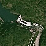
Tala Hydroelectric Power Station is a run-of-the-river type hydroelectric power station on the Wangchu River in Chukha District, Bhutan. The station consists of a 92-metre (302 ft) tall gravity dam which diverts water through a 22 km (14 mi) long headrace tunnel to the power station (26°50′26.36″N 089°35′12.55″E) which contains six 170 MW Pelton turbine-generators. The difference in elevation between the dam and the power station affords the project a hydraulic head of 860 m (2,822 ft).
Map of Tala Hydroelectric Power Station, Bhutan
Preliminary construction on the project began in 1997 and major works were underway by 1999. The first generator was commissioned on 31 July 2006 and the final on 30 March 2007. The project cost was about US$900 million and was financed by India through grants and loan at a 9% interest rate. All of the electricity generated is exported to India through three 440kV transmission lines.
The power station is the country's biggest hydropower project and the fourth after the Chuka project (336 MW) in 1988, followed by Kurichhu (60 MW) in 2001, and Basochho (40 MW) in 2005. Electricity revenue was expected to provide no less than 60% of the government's entire revenue in 2009. Yet, barely 66% of Bhutanese households and 39% of its villages are electrified.