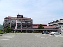
Area 98.56 km² | Phone number 026-245-1100 Population 7,084 (Oct 2016) Local time Saturday 11:16 PM | |
 | ||
Weather 0°C, Wind SE at 6 km/h, 93% Humidity Points of interest Kaminaridaki, Shichimi Hot Spring, Warabi Hot Spring, Warabionsen Fureai Hot Spring, 七味大滝 Yataki Falls | ||
Takayama (高山村, Takayama-mura) is a village located in Kamitakai District in northeast Nagano Prefecture, in the Chūbu region of Japan. As of 1 October 2016, the village had an estimated population of 7,084 and a population density of 71.9 persons per km². Its total area was 98.56 square kilometres (38.05 sq mi). Takayama is listed as one of The Most Beautiful Villages in Japan
Contents
- Map of Takayama Kamitakai District Nagano Prefecture Japan
- Geography
- Surrounding municipalities
- History
- Economy
- Education
- Railway
- Highway
- References
Map of Takayama, Kamitakai District, Nagano Prefecture, Japan
Geography
Takayama is located in northeastern Nagano Prefecture, bordered by Gunma Prefecture to the east. The village is located in a mountainous area, and includes Mount Kitahotaka partly within its borders.
Surrounding municipalities
History
The area of present-day Takayama was part of ancient Shinano Province. The modern villages of Takai and Yamada were established on April 1, 1889 by the establishment of the municipalities system. The two villages merged on September 30, 1956 to form the village of Takayama.
Economy
The economy of Takayama is based on agriculture, forestry, and seasonal tourism.
Education
Takayama has one public elementary school and one public middle school operated by the village government. The village does not have a high school.
