
Location Upper Austria Basin countries Austria Max. width 80 m (260 ft) Length 170 m Inflow source Aurach | Type mountain lake Max. length 170 m (560 ft) Surface elevation 800 m Width 80 m | |
 | ||
Similar Langbathseen, Aurach, Alps, Offensee, Feuerkogel | ||
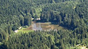
The Taferlklaussee was created in 1716 by the damming of the Aurach Creek. The lake can be reached on foot by a 3.5-hour hike from the village of Altmünster in Upper Austria.
Map of Taferlklaussee, 4814 Altm%C3%BCnster, Austria
The lake's clear water is of drinking water quality. In winter, the lake is used for skating and curling.
References
Taferlklaussee Wikipedia(Text) CC BY-SA