
Population 10,323 (2011 census) LGA(s) City of Brimbank Sydenham Taylors Lakes Postal code 3037 | Postcode(s) 3037 State electorate(s) Sydenham Area 3.6 km² Federal division Division of Calwell | |
 | ||
Location 25 km (16 mi) from Melbourne | ||
For other places called Sydenham, see Sydenham (disambiguation).
Contents
Map of Sydenham VIC 3037, Australia
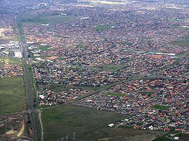
Sydenham is a suburb 25 km north-west of Melbourne, Victoria, Australia. Its local government area is the City of Brimbank. At the 2011 census, Sydenham had a population of 10,323.
History
The Post Office opened on 26 August 1861. A railway station, known as Keilor Road, was opened in 1859 and renamed Sydenham on 1 April 1887. The station was relocated before reopening as Watergardens in 2002, with the extension of the electric rail service to the suburb. Watergardens is on the Sunbury railway line and was a terminus station until November 2012. There is a church behind the Watergardens railway station.
Today
Education facilities in the area include Catholic Regional College Sydenham, a coeducational Catholic senior high school and shares some of its grounds with Emmaus Catholic Primary School. It also includes the Sydenham-Hillside Primary School, which is one of the country's largest government primary school and the Sydenham Campus of Copperfield College.
Sport
Hillside Football Club, an Australian Rules football team, competes in the Essendon District Football League. Sydenham Park Soccer Club competes in the north west state 2
Calder Park Raceway is located just to the north of Sydenham.