
Basin size 6,850 km (2,640 sq mi) Source Lake Vozhe Country Russia | Length 64 km Mouth Lake Lacha Mouth elevation 117 | |
 | ||
Main source Lake Vozhe
120 m (390 ft) River mouth Lake Lacha
117 m (384 ft) | ||
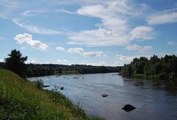
The Svid (Russian: Свидь) is a river in Kargopolsky District in the south-west of Arkhangelsk Oblast in Russia. It connects Lake Vozhe and Lake Lacha and belongs to the river basin of the Onega River. It is 64 kilometres (40 mi) long, and the area of its basin 6,850 square kilometres (2,640 sq mi).
Map of r. Svid', Arkhangelsk Oblast, Russia
The Svid is part of a major waterway from the Vozhega River via Lakes Vozhe and Lacha to the Onega River, one of the biggest river basins of the White Sea.
Its source is the Lake Vozhe at the border of Vologda Oblast. The Svid flows from Lake Vozhe to the north, through a very sparsely populated landscape. In its upper course the river is between 40 metres (130 ft) and 120 metres (390 ft) wide, and flows between boggy and wooded banks. In the middle part of the river the banks becomes more rocky, and the river forms many small rapids. Here the river narrows to 10 to 15 metres (33 to 49 ft) and flows faster, and the banks are higher and steeper. In its lower reaches the river slows again, and the bank becomes low and marshy. The Svid empties into the southern end of Lake Lacha, which drains through the Onega River towards the White Sea.
The Svid below the rapids (downstream from the village of Gorka) is navigable, though there is no regular passenger navigation.