
Country Czech Republic District Ústí nad Orlicí Area 4.37 km² Population 312 (2006) | Region Pardubice Postal code 565 01 Elevation 394 m | |
 | ||
Website | ||
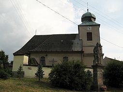
Svatý Jiří is a village and municipality (obec) in Ústí nad Orlicí District in the Pardubice Region of the Czech Republic.
Map of 565 01 Svat%C3%BD Ji%C5%99%C3%AD, Czechia
The name means Saint George, and the arms is canting, showing the red St George's Cross.
The municipality covers an area of 4.37 square kilometres (1.69 sq mi), and has a population of 312 (as at 2 October 2006).
Svatý Jiří lies approximately 9 kilometres (6 mi) west of Ústí nad Orlicí, 37 km (23 mi) east of Pardubice, and 134 km (83 mi) east of Prague.
References
Svatý Jiří (Ústí nad Orlicí District) Wikipedia(Text) CC BY-SA