
OS grid reference TF368131 District South Holland | Sovereign state United Kingdom | |
 | ||
UK parliament constituency | ||
Sutton St Edmunds is a village and civil parish in the South Holland district of Lincolnshire, England, about 14 miles (23 km) south-east from the town of Spalding.
Map of Sutton St. Edmund, UK
Sutton St Edmunds was a chapelry to the parish of Long Sutton until 1866. The parish includes the hamlet of Throckenholt.
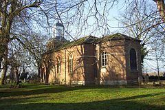
The parish church is a red-brick Grade II listed building dedicated to Saint Edmund. It was completely rebuilt in 1795, and has 19th-century alterations and extensions. It was extended again in 1987.
The village has a village hall.
Guarnock House is a red-brick Grade II listed building. It was built in 1699 and has a 20th-century roof.
Sutton St Edmunds school was built in 1896 by Sutton St Edmunds School Board. It became a council school in 1903. It was known as Sutton St Edmund Chapel End School in the 20th century. It closed in 1969-70.
Throckenholt Priory was sited here. It was a hermitage and chapel in existence from at least 1107-1540. It was granted to Thorney Abbey by Nigel, Bishop of Ely.