
Population 425. 2011 Census Civil parish Sutton Area 9.2 km² UK parliament constituency Arundel and South Downs | OS grid reference SU979151 Sovereign state United Kingdom Dialling code 01798 | |
 | ||
Sutton is a village and civil parish in the District of Chichester in West Sussex, England, located six kilometres (4 miles) south of Petworth and east of the A285 road. The parish has a land area of 920 hectares (2272 acres). In the 2001 census 192 people lived in 83 households, of whom 83 were economically active. The 2011 Census population included the village of Barlavington and hamlet of Codmore Hill.
Contents
Map of Sutton, UK
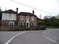
The village has an Anglican church, St John the Baptist, and one pub, the White Horse.
Landmarks
Coates Castle is a Site of Special Scientific Interest within the parish which at one time contained the entire known remaining British population of the field cricket Gryllus campestris. The National Trust castle is within the neighbouring parish of Fittleworth.