
- elevation 180 m (591 ft) | - elevation 0 m (0 ft) | |
 | ||
- left Gåstjønna, Bølu, Folda, Vinddøla - location Surnadal Municipality, Møre og Romsdal, Norway | ||
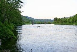
The Surna is a river in Rindal and Surnadal municipalities in Møre og Romsdal county, Norway. The 45-kilometre (28 mi) long river begins near Øvre Rindal at the confluence of the rivers Tiåa and Lomunda. The river then flows west and empties into the Surnadalsfjorden at the village of Surnadalsøra. Several smaller rivers flow into the Surna from the Trollheimen mountains to the south. The Foldsjøen and Gråsjøen reservoirs along the Folda River also flow into the Surna. The river is a good fishing river. The Brandåa, Gryta, and Kysinga hydroelectric power stations operate on tributaries of the river.
Map of Surna, Norway
References
Surna (Norway) Wikipedia(Text) CC BY-SA