
Local time Friday 11:46 AM | ||
 | ||
Weather 14°C, Wind S at 47 km/h, 7% Humidity | ||
National solar observatory sunspot new mexico
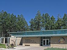
Sunspot is an unincorporated community in the Sacramento Mountains in Otero County, New Mexico, United States. It is located within the Lincoln National Forest, 18 miles south of Cloudcroft. Its elevation is 9200 feet.
Contents
- National solar observatory sunspot new mexico
- Map of Sunspot NM USA
- Rv living sledding on sand and snow white sands and sunspot new mexico
- References
Map of Sunspot, NM, USA
It is named after the nearby National Solar Observatory on Sacramento Peak, in a vote that was allegedly rigged by the observatory's director John Evans. The sole road that drives into Sunspot is New Mexico State Road 6563, named for the brightest wavelength of hydrogen emission, H-alpha.
Most of the grounds are available to the public, but the residential area is off limits to the general public.
Rv living sledding on sand and snow white sands and sunspot new mexico
References
Sunspot, New Mexico Wikipedia(Text) CC BY-SA