
Opened 1960 Total length 627 m Bridge type Cantilever bridge | Height 60 m Clearance below 41 m | |
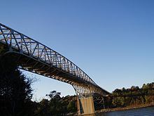 | ||
Crosses Chesapeake & Delaware Canal Locale Summit Bridge, Delaware Maintained by U.S. Army Corps of Engineers Design Cantilever truss bridge Location Newark, Dover, Summit Bridge, Delaware Similar Chesapeake & Delaware, Chesapeake City Bridge, Chesapeake & Delaware, St Georges Bridge, Chesapeake & Delaware | ||
Inspecting summit bridge
The Summit Bridge carries U.S. Route 301 and Delaware Routes 71 and 896 across the Chesapeake & Delaware Canal, connecting Newark, Delaware with Dover, Delaware (via Delaware Rt. 71) and the Chesapeake Bay Bridge (via U.S. Rt. 301). The bridge also carries Delaware Bicycle Route 1, a bicycle route that spans the length of the state of Delaware, across the canal. Opened in 1961, the Summit Bridge was the second four-lane high-level crossing in Delaware and was designed for a future upgrade of U.S. Rt. 301 to a four-lane limited access toll road connecting the Chesapeake Bay Bridge and the Delaware Turnpike (I-95), but such plans have been shelved by both the Maryland and Delaware Departments of Transportation (it has since been resurrected by DelDOT as a realignment of US 301 connecting Maryland and Delaware Route 1 near the Chesapeake and Delaware Canal Bridge). The current bridge replaces a former swing span structure that was demolished when the U.S. Army Corps of Engineers rerouted the canal to a new sea-level channel south of Lums Pond State Park. A construction project on the approaches to the bridge was completed in Fall of 2012.