
 | ||
Sulzberger Bay (77°0′S 152°0′W) is a bay between Fisher Island and Vollmer Island, along the coast of King Edward VII Land. Discovered by the Byrd Antarctic Expedition on December 5, 1929, and named by Byrd for Arthur H. Sulzberger, publisher of The New York Times, a supporter of the Byrd expeditions in 1928–1930 and 1933–1935.
The Sulzberger Bay indents the front of the Sulzberger Ice Shelf (77°0′S 148°0′W), an ice shelf about 137 km (85 mi) long and 80 km (50 mi) wide bordering the coast of Marie Byrd Land between Edward VII Peninsula and Guest Peninsula. The ice shelf was observed and roughly mapped by the Byrd Antarctic Expedition (1928–1930).
Sulzberger Basin (77°0′S 152°30′W) is an undersea basin on the central Ross shelf named in association with the Sulzberger Bay.
Iceberg formation
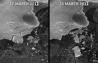
The ice shelf released icebergs within a day of the 2011 Tōhoku earthquake and tsunami. Scientists have linked the ice calving to the tsunami reaching the ice shelf, some 13,600 kilometers (8,500 mi) away from the earthquake epicenter. The main iceberg was approximately the area of Manhattan Island. In total, the icebergs calved from the ice shelf totalled an area of nearly 125 km2 (48 mi2). This section of the shelf had not moved since 1946.