
GNIS ID 1575030 Country United States of America | Length 146 km | |
 | ||
Progression Sugar River → Pecatonica → Rock → Mississippi → Gulf of Mexico | ||
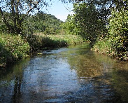
The Sugar River is a tributary of the Pecatonica River, approximately 91 miles (146 km) long, in the U.S. states of Wisconsin and Illinois.
Map of Sugar River, Harrison Township, IL, USA
It rises in the hills of southwest Wisconsin, in southwest Dane County, approximately 15 miles (24 km) southwest of Madison. The headwaters are at the southern terminus of the last North American glacier. West of the river, the land elevates from lack of glaciation and joins what is known as the "driftless area", known for its abrupt hills and valleys, covering most of southwest Wisconsin. From its source, the river meanders southeast, past Paoli and Belleville, where it is dammed to form Lake Belle View. From there it meanders east of Monticello where it is joined by the Little Sugar River and flows south through Albany, and Brodhead. It crosses into northern Illinois flowing past an extensive area of the Winnebago County Forest Preserve system. These preserves are Sugar River Alder, Colored Sands, and Sugar River. The river joins the Pecatonica River in northern Winnebago County near Shirland, approximately 5 miles (8 km) south of the state line and approximately 15 miles (24 km) north-northwest of Rockford.
The Sugar River State Trail is a 24 miles (39 km) abandoned railroad line used for walking, bicycling, snowmobiling, and cross-country skiing.
Two organizations have been established to protect the watershed around the upper and lower stretches of the Sugar River. The Upper Sugar River Watershed Association manages the watershed north of Belleville and the Lower Sugar River Watershed Association manages the watershed south of Albany. The area in between, the Middle Sugar River Watershed, does not have an established organization.