
- elevation 1,110 m (3,642 ft) - elevation 24 m (79 ft) | - location Macquarie Plains | |
 | ||
- right Charon Rivulet, Cliff Creek, South Styx River, Big Creek (Tasmania) | ||
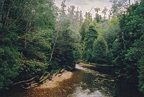
The Styx River is a perennial river that is located in the centre of southern Tasmania, Australia. The upper reaches of the Styx River are located in the Tasmanian Wilderness, south west of Maydena. The river is a popular destination for river-rafting and canoeing.
Contents
Map of Styx River, Tasmania, Australia
Location and features
The Styx River rises below Mount Mueller at an elevation of 1,110 metres (3,640 ft) above sea level and flows generally east by north, joined by five minor tributaries, before reaching its confluence with the River Derwent near Macquarie Plains, west of New Norfolk. The river descends 1,090 metres (3,580 ft) over its 59-kilometre (37 mi) course.
The Styx Valley contains old growth forests including the tallest hardwood trees on earth, Eucalyptus regnans. The Wilderness Society and Senator Bob Brown have campaigned to save the forest from clearing for woodchips. Some trees are so large they have become tourist attractions and named, including the Christmas Tree and Chapel Tree.
The first settlers in the Styx Valley arrived in 1812.