
Established 1892 Area code 053 | Postal code (street) 8765 | |
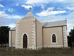 | ||
Strydenburg is a town in the east of the Northern Cape province in South Africa. Seventy-seven km north of Britstown, it was laid out by the Dutch Reformed Church on the farm Roodepan in 1892. It also lies on the N12, which separates the actual town from its township.
Map of Strydenburg, 8765, South Africa
Town 55km south-west of Hopetown and 75km north-north-west of Britstown. It was laid out in 1892 on the farm Roodepan and attained municipal status in 1914. Dutch for ‘town of argument’, the name refers to disagreement as to on which farm it should be situated.
References
Strydenburg Wikipedia(Text) CC BY-SA