
 | ||
The Structured Geospatial Analytic Method (SGAM) is both as an analytic method and pedagogy for the Geospatial Intelligence professional. This model was derived from and incorporates aspects of both Pirolli and Card’s sensemaking process and Richards Heuer’s Analysis of Competing Hypotheses model. This is a simplified view of the geospatial analytic process within the larger intelligence cycle.
The SGAM is intended to advance the Geospatial Intelligence tradecraft by providing an approach not only to teach the analyst how forage and repackage data, but also how to analyze the data in a meaningful way. It has been long known that without specific prompting, people may be unaware of spatial patterns of an environment and, similar to other areas of intelligence analysis, the geospatial analyst has the human tendency to:
Spatial thinking that goes beyond a simple identification of locations is key to applying the SGAM. This thinking involves comparing locations, considering the influence of nearby features, grouping regions and hierarchies, and identifying distant places that have similar conditions. It is also the consideration of change, movement, and diffusion through time and place. Spatial thinking then proceeds to examine the places and compare places in the context of space and time.
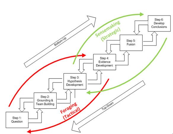
The method is organized into two major loops:
The foraging loop recognizes that analysts tend to search for data by beginning with a broad set of data and then proceeding to narrow that set down into successfully smaller, higher-precision sets of data, before analyzing the information. The three foraging actions including exploring for new information; narrowing the set of items that has been collected; and exploiting items in the narrow set; trade off against one another under deadline or data overload constraints. It is important to note that much geospatial intelligence work may never depart from the foraging loop and can simply consist of extracting information and repackaging it without much actual analysis since the production of maps is oft the role that the analyst fulfills.
Sensemaking is the ability to create situational awareness and understanding in situations of high complexity or uncertainty in order to make decisions. It is “a motivated, continuous effort to understand connections (which can be among people, places, and events) in order to anticipate their trajectories and act effectively”. Pirolli discusses the importance of using a cooperative approach to sensemaking as it yields a greater diversity of knowledge and reduces the risk of missing relevant information. This collaborative element is essential to the SGAM, as teaming is identified as one of the steps within the overall method. The Director of National Intelligence’s (DNI) vision for 2015 is one in which intelligence analysis increasingly becomes a collaborative enterprise with the focus of collaboration shifting “away from coordination of draft products toward regular discussion of data and hypotheses early in the research phase”. This is a major change from the traditional concept of geospatial analysis as largely an individual activity, and requires the geospatial analyst to be skilled in building, leading, resourcing, and managing teams for effective outcomes.
The data flow represents the converting of raw information into a form where expertise can be applied and then out to another form suited for communication. Information processing can be driven by bottom-up processes (from data to theory) or top-down (from theory to data). The below Table provides more detail about the steps.
It is often difficult for an analyst to determine the next step in an analytic process or to conceptualize how various techniques and tools fit together. The SGAM provides the means to relate the analytical step to the appropriate Structured Analytic Technique (SAT) and then to the appropriate geospatial operation. The below table summarizes this mapping:
There are several benefits: