
Population 3,213 (2011 census) State electorate(s) Strathfield Postal code 2136 | Postcode(s) 2135 Strathfield South Enfield Federal division Division of Watson | |
 | ||
Location 14 km (9 mi) west of Sydney CBD Lga Municipality of Strathfield | ||
Strathfield South is a suburb, in the Inner West of Sydney, in the state of New South Wales, Australia 14 kilometres west of the Sydney central business district, in the Strathfield local government area.
Contents
- Map of Strathfield South NSW 2136 Australia
- History
- Commercial area schools churches and parklands
- References
Map of Strathfield South NSW 2136, Australia
North Strathfield and Strathfield are separate suburbs, to the north. Strathfield South is located between Liverpool Road (Hume Highway) and the Cooks River, bordered on the east by Coronation Parade and to the west by the Enfield Marshalling Yards.
History
This area was once part of the suburb of Enfield and was located within the former Enfield Municipal Council from 1889 to 1949. Gradually the boundaries have altered and eventually this area became known as Strathfield South.
Most of Strathfield South is located on two early land grants - the 1808 grant to James Wilshire (later known as the Redmire Estate) and the 1837 grant to Father John Joseph Therry, which became the Village of St Anne's.
Wilshhire's grant was subdivided in 1867 and marketed as the 'Redmire Estate'. Roads in Strathfield South such as Dean Street and Water Street were established in this subdivision. A few early Victorian and Federation style homes survive from this early period of development.
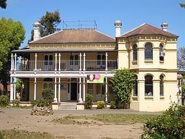
Father John Joseph Therry was granted 47 acres (190,000 m2) in March 1837. To finance the building of the original St. Anne's Church (foundation stone laid July 1841) Father Therry offered 4-acre (16,000 m2) blocks for £25, but insufficient money being available, a further 134 allotments were offered for sale in 1854 and the streets of the subdivision named after Saints or dignitaries of the Church. The Historic Church of St Ann's has been included on the State Heritage Register.
The area around St Anne's Village and to the west of Cooks River was locally known as Bark Huts. Bark Huts was a hotel on Liverpool Road, halfway between Sydney and Liverpool, and a small settlement was established around the hotel. Other parts of this area were known as Druitt Town. This name was given to the area by Joshua Judge Josephson, who owned large areas of land in the area, in honour of his friend Major George Druitt.
Commercial area, schools, churches and parklands
Strathfield South is primarily residential with a small group of shops located around the intersection of Liverpool Road and Homebush Road.
The Catholic parish of St Annes is located in St Annes Square. Strathfield South Uniting Church is in Liverpool Road.
There are three schools servicing the Strathfield South area: Strathfield South Public School, Strathfield South High School and St Anne's Catholic Primary School.
Strathfield South Public School is the K-6 New South Wales Department of Education and Training school in the area. With over 125 years of history, the motto of Strathfield South Public School is Think of Others. Strathfield South High School is the 7-12 public school in the suburb.
The area is well serviced by parks such as Ford Park, Dean Reserve and St Anne's Reserve, which runs along the Cooks River. The Bay to Bay Cycle/Walking Path, which runs between Botany Bay and Homebush Bay (Sydney Olympic Park) runs through Strathfield South, along the Cooks River.
Recently Strathfield South welcomes its first high-rise development, with an eight-storey development on the Hume Highway.