
Country United States FIPS code 29-70828 Elevation 289 m Population 1,838 (2013) Area code 417 | Time zone Central (CST) (UTC-6) GNIS feature ID 0729969 Zip code 65785 Local time Tuesday 4:45 AM | |
 | ||
Weather 11°C, Wind N at 5 km/h, 95% Humidity Area 5.543 km² (5.439 km² Land / 10 ha Water) | ||
Stockton is a city in Cedar County, Missouri, United States. The population was 1,819 at the 2010 census. It is the county seat of Cedar County.
Contents
Map of Stockton, MO 65785, USA
History
Stockton was platted in 1846. It was originally named Lancaster, but was renamed Fremont in 1847 in honor of John C. Frémont. In 1857 it was renamed again in honor of Robert F. Stockton.
The Montgomery Archeological Site and Stockton Community Building are listed on the National Register of Historic Places.
Geography
According to the United States Census Bureau, the city has a total area of 2.14 square miles (5.54 km2), of which, 2.10 square miles (5.44 km2) is land and 0.04 square miles (0.10 km2) is water.
The town and lake are located in the rural foothills of the Ozarks, just 45 minutes outside of Springfield. South Missouri and the town of Stockton are often referred to culturally and geographically by historians and geographers as "The Gateway to Dixie". The area seems to resemble Oklahoma, Arkansas, Kentucky, Tennessee, and Appalachia in many ways more than it does the rest of Missouri which carries a more industrial cornbelt feel found throughout the Midwest. Stockton is surrounded by rolling hills, rocky terrain, winding rivers, pristine lakes, cattle ranches, and heavily forested woods. The majority of the towns original settlers came into the area from the Southeast.
Every fall, thousands of people visit Stockton to attend the famous Black Walnut Festival on the third weekend of September. The festival celebrates local art, food, music, and businesses; and is an active social scene for the entire county.
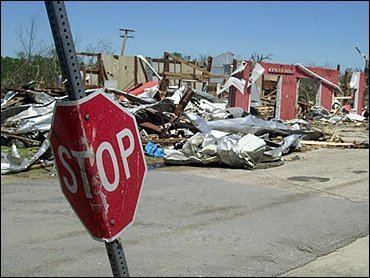
On May 4, 2003, a large, destructive tornado severely damaged the city of Stockton. After decimating the historic business district and damaging or destroying over 250 homes the tornado proceeded east through the countryside. The storm also caused the deaths of three Stockton residents and injuries of numerous others. The Stockton tornado began in Barton County, Missouri, near [Liberal, Missouri] and moved north/eastward through Cedar and Polk counties before dissipating east of the Dallas County line. Since then, the city has been working with residents and both federal and state authorities to develop a plan to rebuild the downtown business district and improve upon other public facilities such as a new park and community center. Pierce City, Missouri was also severely damaged by a similar storm in which five residents lost their lives. The city has a similar plan for recovery.
2010 census
As of the census of 2010, there were 1,819 people, 774 households, and 470 families residing in the city. The population density was 866.2 inhabitants per square mile (334.4/km2). There were 949 housing units at an average density of 451.9 per square mile (174.5/km2). The racial makeup of the city was 97.0% White, 0.1% African American, 0.8% Native American, 0.4% Asian, 0.1% Pacific Islander, 0.1% from other races, and 1.6% from two or more races. Hispanic or Latino of any race were 1.4% of the population.
There were 774 households of which 30.5% had children under the age of 18 living with them, 43.9% were married couples living together, 12.0% had a female householder with no husband present, 4.8% had a male householder with no wife present, and 39.3% were non-families. 35.3% of all households were made up of individuals and 22% had someone living alone who was 65 years of age or older. The average household size was 2.26 and the average family size was 2.92.
The median age in the city was 43.7 years. 24.5% of residents were under the age of 18; 6.9% were between the ages of 18 and 24; 20% were from 25 to 44; 22.9% were from 45 to 64; and 25.9% were 65 years of age or older. The gender makeup of the city was 46.4% male and 53.6% female.
2000 census
As of the census of 2000, there were 1,960 people, 814 households, and 473 families residing in the city. The population density was 921.7 people per square mile (355.3/km²). There were 968 housing units at an average density of 455.2 per square mile (175.5/km²). The racial makeup of the city was 95.66% White, 0.41% African American, 0.51% Native American, 1.12% Asian, 0.51% from other races, and 1.79% from two or more races. Hispanic or Latino of any race were 1.94% of the population.
There were 814 households out of which 25.4% had children under the age of 18 living with them, 46.8% were married couples living together, 8.6% had a female householder with no husband present, and 41.8% were non-families. 38.9% of all households were made up of individuals and 23.7% had someone living alone who was 65 years of age or older. The average household size was 2.14 and the average family size was 2.85.
In the city, the population was spread out with 27.5% under the age of 18, 6.7% from 18 to 24, 20.7% from 25 to 44, 18.7% from 45 to 64, and 26.4% who were 65 years of age or older. The median age was 41 years. For every 100 females there were 93.1 males. For every 100 females age 18 and over, there were 77.4 males.
The median income for a household in the city was $25,353, and the median income for a family was $34,427. Males had a median income of $22,574 versus $19,688 for females. The per capita income for the city was $14,540. About 7.0% of families and 14.8% of the population were below the poverty line, including 21.0% of those under age 18 and 10.5% of those age 65 or over.