
- left Kåpperåa, Funna, Forra Basin area 2,111 km² | Length 70 km Mouth Trondheim Fjord Mouth elevation 0 | |
 | ||
- right Dalåa, Torsbjørka, Sona - location Stjørdal, Nord-Trøndelag, Norway | ||
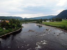
Stjørdalselva (English: Stjørdal River) is a 70-kilometre (43 mi) long river that reaches from near the Norwegian–Swedish border down the Stjørdalen valley through the municipalities of Meråker and Stjørdal before entering the Trondheimsfjord. The mouth is located between the villages of Stjørdalshalsen and Hell just south of Trondheim Airport, Værnes. The mouth of the river was moved to allow the runway to expand into the delta.
Map of Stj%C3%B8rdalselva, Norway
The European route E14 highway and the Meråker Line railway follow the river from its source the entire length of the river.
References
Stjørdalselva Wikipedia(Text) CC BY-SA