
- summer (DST) EDT (UTC-5) Area code 724 Added to NRHP 24 October 1997 | Postal code 15482 Year built 1892 | |
 | ||
Area 3.134 km² (3.082 km² Land / 5 ha Water) | ||
Star Junction is an unincorporated community and census-designated place in Perry Township, Fayette County, Pennsylvania, United States. It is located on Pennsylvania Route 51. At the 2010 census, the population was 616.
Contents
History
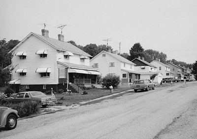
Star Junction was founded in 1893, when the Washington No. 2 Mine was opened by the Washington Coal and Coke Company. It is so-named because it was once the site of a railroad depot, the end of the line for the Washington Run Railroad. Star Junction was once a coal mining center, with beehive ovens for coke manufacture and a foundry. It was the site of labor unrest, including the walkout of 4,500 miners in 1922. Although the company store and mines are long gone, the "patch" (the groups of company houses) still remains and houses many residents. This area was added to the "Determined Eligible List" of the Bureau of Historic Preservation, as an example of a typical coal town, and has been added to the National Register of Historic Places.
Geography
Star Junction is in northwestern Fayette County, in the southwest part of Perry Township. Via PA 51 it is 2 miles (3 km) north to Perryopolis and 13 miles (21 km) south to Uniontown, the county seat.
According to the U.S. Census Bureau, the Star Junction CDP has a total area of 1.2 square miles (3.1 km2), of which 0.02 square miles (0.04 km2), or 1.42%, is water.
Education
Star Junction is served by the Frazier School District.