
Population 427 (2001 census) Sovereign state United Kingdom Civil parish Peckleton | OS grid reference SP434984 Local time Sunday 3:04 AM Dialling code 01455 UK parliament constituency Bosworth | |
 | ||
Weather 4°C, Wind NE at 13 km/h, 63% Humidity | ||
Stapleton is a village in south-west Leicestershire, England, about ten miles south-west of Leicester city centre. Its population was 427 people at the 2001 census. The population at the 2011 census was included in the civil parish of Peckleton
Map of Stapleton, Leicester, UK
Stapleton is built on part of a long ridge that begins in Barwell to the south, and is followed by the A447 road north, gaining height until it reaches Osbaston, where it descends into a tributary of the River Sence. In terms of rivers, Stapleton's nearest major river is the River Sence, but on a more local level, the River Tweed is the closest waterway, a tributary of which rises in the north of the village. The River Tweed's main source rises from Brick Kiln Hill, just north-east of Hinckley from where it flows north along the eastern edge of Barwell before turning west and continuing to travel in a north-easterly direction.
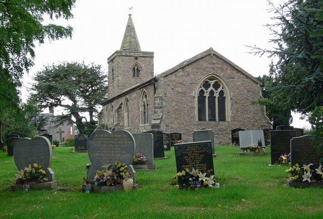
The village is centred on St. Martins church (built in about 1300 according to Pevsner) which is to be found on Church Lane in the southern end of the village and was most probably established as a connection point for travellers journeying between Ashby-de-la-Zouch Castle and the areas around Coventry, Warwick and Kenilworth.
The earliest known reference to the village appears in a charter from King of Mercia - Wiglaf to the Abbot of Crowland in Lincolnshire written in 833, making grants of "two ploughlands in Stapleton and Sutton". Stapleton is mentioned in the Domesday Book as having a population of five or six families and being owned by Hugh de Grandmesnil, who had been given most of West Leicester by William the Conqueror after the Conquest.
There are very few historical incidents recorded around Stapleton, all except for one day in August 1485 when King Richard III arrived and camped at the Bradshaws just south of the village with his army in preparation for the momentous Battle of Bosworth Field.
Present day Stapleton consists of several small residential roads centred on the junction of Dadlington Lane and Main Street (A447). These include Church Lane, Chapel Street, Beale's Close, St Martins, Manor Crescent, Green Lane, School Lane and Mill Close.
There is no shop, there is the Nags Head Inn on Main Street. The village has a village hall and is home to a cricket club.