
Population 264 (in 2011) Civil parish Stapleford Region South West Dialling code 01722 Post town Salisbury | OS grid reference SU070374 Unitary authority Country England Ceremonial county Wiltshire UK parliament constituency Salisbury | |
 | ||
Stapleford is a village and civil parish about 4 miles (6.4 km) north of Wilton, Wiltshire, England. The village is on the River Till just above its confluence with the River Wylye.
Map of Stapleford, Salisbury, UK
The village is on the B3083 road, which joins the A36 at the southern end of the village. The parish includes the hamlet of Serrington, on the A36 0.25 miles (400 m) west of the B3083 junction.
By the Till to the north are the earthwork remains of Stapleford Castle, a medieval ringwork and bailey castle.
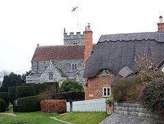
The Anglican Church of St Mary dates from the 12th century and is Grade I listed.
There is a village hall and a pub/restaurant, the Pelican Inn at Serrington.
References
Stapleford, Wiltshire Wikipedia(Text) CC BY-SA