
MPP Eric Hoskins
Liberal First contested 1999 Population (2011) 116,463 Census division Toronto | District created 1996 Last contested 2014 Province Ontario Elector 78,575 | |
 | ||
Legislature Legislative Assembly of Ontario | ||
St paul s provincial electoral district top 5 facts
St. Paul's is a provincial electoral district in Ontario, Canada, that has been represented in the Legislative Assembly of Ontario since 1999.
Contents
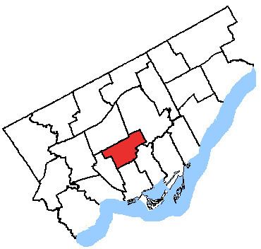
The small but densely populated riding covers the area to the north of Downtown Toronto. (Map) The riding is represented by Liberal Eric Hoskins, who was elected in a 2009 by-election following the resignation of Michael Bryant.
The riding was created for the 1999 election, to match the borders of the federal riding of the same name. It was carved out of the former districts of St. Andrew—St. Patrick, Eglinton, Oakwood, Dovercourt and St. George—St. David.
The riding consists of part of the Fairbank, Humewood-Cedarvale, Hillcrest-Bracondale, Wychwood Park, part of Davenport, Casa Loma, Forest Hill, Tarragon Village, Rathnelly, South Hill, Summerhill, Rosehill, Chaplin Estates, Deer Park and Davisville and part of North Toronto neighbourhoods.
Political geography
In the 2007 provincial election, the Liberals dominated most of the riding, performing the best in Fairbank in the northwest corner of the riding and in Davisville, in the east end of the riding. The Tories won most of their polls in the Forest Hill neighbourhood, and in Cedarvale. The NDP won a few polls, mostly in the south, where the riding borders the NDP riding of Trinity—Spadina. [1]