
Width 0.5 km (0.31 mi) Area 8 km² | Length 16 km (9.9 mi) Population 4,000 | |
 | ||
Similar Inani Beach, Sundarbans, Cox's Bazar Beach, Ahsan Manzil, Lalbagh Fort | ||
St martin s island ep 01
St. Martin's Island (Bengali: সেন্ট মার্টিন্স দ্বীপ) is a small island (area only 8 km2) in the northeastern part of the Bay of Bengal, about 9 km south of the tip of the Cox's Bazar-Teknaf peninsula, and forming the southernmost part of Bangladesh. There is a small adjoining island that is separated at high tide, called Chera Dwip. It is about 8 kilometres (5 miles) west of the northwest coast of Myanmar, at the mouth of the Naf River.
Contents
- St martin s island ep 01
- Map of St Martins Island
- InhabitantsEdit
- TransportationEdit
- TourismEdit
- Shootings of St Martins fishermenEdit
- Climate and weatherEdit
- References
Map of St. Martin's Island
The first settlement started 250 years ago by Arabian sailors who named the island 'Jazeera'. During British occupation the island was named St. Martin Island. During the First Anglo-Burmese War between the British and Burmese empires in 1824–1826, rival claims to the island were a major factor. The local names of the island are "Narikel jinjira" which means 'Coconut Island' in Bengali, and "Daruchini Dwip". It is the only coral island in Bangladesh.
InhabitantsEdit
Most of the island's approximately 3,700 inhabitants live primarily from fishing. The other staple crops are rice and coconut. Being very common on the island, algae are collected, dried, and exported to Myanmar. Between October and April, the fishermen from neighboring areas bring their caught fishes to the island's temporary wholesale market. However, imports of chicken, meat and other foods come in from the mainland Bangladesh and Myanmar (Burma). As the centre and the south are mainly farmland and makeshift huts, most of the permanent structures are around the far north.
During the rainy season, because of the dangerous conditions on the Bay of Bengal, the inhabitants have no scope to go to the mainland (Teknaf) and their life can become dangerous. There is a hospital on the island, but in the past there has often been no doctor.
TransportationEdit
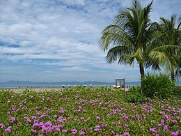
The only way to reach St. Martin's Island is by water transportation: boats and ships (mostly for tourists) from Teknaf. There are few or no taxis, tarred roads, or electricity. Except for the larger hotels that run on generators, there is no electricity supply from the national grid since a hurricane in 1999. The island is all about sun, sea and palm trees. During the day, it comes alive with water and beach sports, with beach parties and bonfires lighting up the evening skies.
TourismEdit
From 1989 to 2004, non-residential Bangladeshis and foreigners were the only people permitted on the island; however, this has changed and now residential Bangladeshis are allowed. St. Martin's Island has become a popular tourist spot. Five shipping liners run daily trips to the island, including Shahid Sher Niabat, L C T Kutubdia, Eagle, Keari Cruise & Dine, and Keari-Sindbad. Tourists can book their trip either from Chittagong or from Cox's Bazar. The surrounding coral reef has an extension named Chera Dwip. A small bush is there, which is the only green part, enhancing the beauty of this island. People do not live on this part, so it is advisable for the tourists to go there early and come back by afternoon.
In the past five years St. Martin's visitor population has increased dramatically. While this situation has proven to be lucrative for the islanders, it is causing the natural beauty to deteriorate. Presently there are many efforts being put forth to preserve the several endangered species of turtles that nest on the island, as well as the corals, some of which are found only on Narikel Jinjera. Pieces of the coral reef are being removed to be sold to tourists. Nesting turtles are sometimes taken for food, and their hatchlings are often distracted by the twinkling lights along the beach. Fish, a few recently discovered, are being overfished. Every year the fishermen must venture further out to sea to get their catch. Most of them use motorless boats.
It is possible to walk around the island in a day because it measures only 8 km2 (3 sq. mile), shrinking to about 5 km2 (2 sq. mi) during high tide. The island exists only because of its coral base, so removal of that coral risks erosion of the beach. Because of this, St. Martin's has lost roughly 25% of its coral reef in the past seven years.
Shootings of St. Martin's fishermenEdit
Fishing is one of largest professional activities of St. Martin's Island's 5,500 residents; however, territorial disputes between Myanmar and Bangladesh have resulted in a state of tension between the countries that can erupt into violence, often targeting unarmed Bangladeshi fishermen. Below is a brief summary of shooting incidents against St. Martin's fishermen:
Climate and weatherEdit
The best weather is usually between November and February; this is the major tourist season. Between March and July, cyclones can strike. The island was devastated by a cyclone in 1991 but has fully recovered, and was untouched by the 2004 tsunami. Thus, March to July is off-season for tourists.