
Length 272 km Mouth Mississippi River Cities St. Croix Falls | Source Upper St. Croix Lake Country United States of America | |
 | ||
- left Sunrise River, Snake River, Kettle River - right Apple River, Yellow River, Namekagon River, Eau Claire River (St. Croix River), Kinnickinnic River - location near Solon Springs, Wisconsin, Douglas County, WI - location Prescott, WI, Pierce County, Washington, Dakota, MN, WI Bridges Stillwater Bridge, Soo Line High Bridge, Prescott Drawbridge | ||
The St. Croix River (French: Holy Cross) is a tributary of the Mississippi River, approximately 169 miles (272 km) long, in the U.S. states of Wisconsin and Minnesota. The lower 125 miles (201 km) of the river form the border between Wisconsin and Minnesota. The river is a National Scenic Riverway under the protection of the National Park Service. A hydroelectric plant at St. Croix Falls supplies power to the Minneapolis–St. Paul metropolitan area.
Contents
- Map of St Croix River United States
- Geography and hydrographyEdit
- Conservation effortsEdit
- NamingEdit
- HistoryEdit
- Fur tradeEdit
- LoggingEdit
- Bridge crossingsEdit
- Commerce and recreationEdit
- References
Map of St Croix River, United States
Geography and hydrographyEdit
The St. Croix River rises in the northwestern corner of Wisconsin, out of Upper St. Croix Lake in Douglas County, near Solon Springs, approximately 20 miles (32 km) south of Lake Superior. It flows south to Gordon, then southwest. It is joined by the Namekagon River in northern Burnett County, where it becomes significantly wider. A few miles downstream the St. Croix meets the boundary between Minnesota and Wisconsin, which it demarcates for another 130 miles (209 km) until its confluence with the Mississippi River.
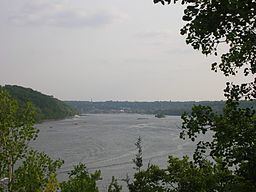
Other major tributaries include the Kettle River, Snake River, and Sunrise River joining from the west, and the Apple River, Willow River, and Kinnickinnic River joining from the east. Just below Stillwater, Minnesota the river widens into Lake St. Croix, and eventually joins the Mississippi River at Prescott, Wisconsin, approximately 20 miles (32 km) southeast of St. Paul, Minnesota.
Conservation effortsEdit
The St. Croix River was one of the original eight rivers to have significant portions placed under protection by the National Wild and Scenic Rivers Act of 1968. The upper reaches of the river in Wisconsin below the St. Croix Flowage, 15 miles (24 km) downstream from its source, as well as the Namekagon River, are protected as the St. Croix National Scenic Riverway. The free-flowing nature of the river is interrupted only by a hydroelectric dam operated by the Northern States Power Company at St. Croix Falls, Wisconsin.
The lower 27 miles (43 km) below the dam, including both sides of the river along the Minnesota-Wisconsin border, were protected as part of the Lower St. Croix National Scenic Riverway. This area includes the Dalles of the St. Croix River, a scenic gorge located near Interstate Park, south of St. Croix Falls, Wisconsin.
Most recently, the state of the Lower St Croix has been questioned by the construction of an Interstate bridge, connected to MN Highway 36, located in the vicinity of Oak Park Heights, Minnesota. Despite objections from thousands of residents, multiple communities and conservation groups (the Sierra Club, etc.) and the National Park Service, construction of the bridge was authorized by amending the 1968 Scenic Rivers Act.
Light and noise pollution are concerns of those remaining opposed to the bridge, citing the original Act that held such activity far to the south along the Interstate 94 corridor.
The St. Croix River Association (SCRA) is a watershed-wide non-profit advocating for conservation throughout the watershed. Founded in 1911 as an all-volunteer citizens group, it has evolved into a staffed, mature nonprofit organization and official "friends group" of the St. Croix National Scenic Riverway. Its mission is to protect, restore and celebrate the St. Croix River and its watershed.
NamingEdit
Father Louis Hennepin wrote in 1683, from information probably provided by Daniel Greysolon, Sieur du Lhut: "There is another River which falls ... into the Meschasipi ... We named it The River of the Grave, or Mausoleum, because the Savages buried there one of their Men ... who was bitten by a Rattlesnake." In the original French, this is translated as "Rivière Tombeaux".
Jean-Baptiste-Louis Franquelin's 1688 map recorded a "Fort St. Croix" on the upper reaches of the river. The name "Rivière de Sainte-Croix" was applied to the river sometime in 1688 or 1689, and this more auspicious name supplanted Father Hennepin's earlier designation.
On Carte de la Louisiane et du Cours du Mississipi (1718) by Guillaume Delisle and on A Map of North America (1768) by John Blair, the St. Croix River—more specifically what was then known as the east branch of the St. Croix River (known today as the Namekagon River)—is shown as the Ouasisacadeba, a French representation of the Dakota name for the St. Croix River. On the 1778 Mitchell Map, the river is simply titled "Ouadeba", which represents the Dakota watpá meaning "river".
The upper portion of river—originally called the north branch of the St. Croix River—was known to the Ojibwa as Manoominikeshiinh-ziibi (Ricing-Rail River). Downstream of its confluence with the Namekagon, the Ojibwa renamed the river as Gichi-ziibi (Big River) or Okijii-ziibi (Pipestem River)
At the time of European settlement of the valley, Dakota and Ojibwe were engaged in a long and deadly war with each other. Consequently, the portion of the river below the confluence with Trade River is called Jiibayaatig-ziibi (Grave-marker River) in the Ojibwe language, reinforcing the earlier "Rivière Tombeaux" name in their language.
On Map of the Territories of Michigan and Ouisconsin (1830) by John Farmer, the St. Croix River is shown as the "Chippewa River". However, by 1843, Joseph Nicollet's Hydrographical Basin of the Upper Mississippi River reinforced the name provided by Franquelin's 1688 map.
HistoryEdit
The river is the result of geologic forces going back 1.1 billion years. At that time, the Mid-Continent Rift rended the middle of North America apart, creating a volcanic zone. The lave spewed forth cooled into hard basalt. That basalt is what today creates the dramatic cliffs around the Interstate State Parks. About 500 million years ago, a shallow sea covered the area, laying down layers of sand and minerals that make up much of the sandstone bluffs now seen along the river. In the last 20,000 years, glaciers have scraped the landscape and released torrents of meltwater, which carved the St. Croix River's course.
The river has been home to people for thousands of years. A bison kill site in May Township, Washington County, Minnesota is believed to be about 4,000 years old. An Oneota village from about 1200 A.D. has been studied by archaeologists.
At the time of European arrival in the region, the river valley and the surrounding area was occupied by the semi-nomadic Ojibwe, Dakota and nine other American Indian tribes. The Indians lived mainly on wild rice, fish, and game. By the 18th century, the Ojibwe and Dakota were the two primary tribes that inhabited the area, until around 1745, when the Dakota were forever driven from the St. Croix Valley as a result of the Battle of Kathio.
Fur tradeEdit
The first Europeans to arrive in the area were Sieur du Lhut and his men in the fall and winter of 1679-1680. For the next eighty years the area was primarily under French influence, and the fur trade grew throughout the first half of the 18th century, with beaver pelts as the prize trade good. French trade in the upper valley was dominated by the Ojibwe and tied to Lake Superior traders, whereas in the lower valley the Dakota assisted in trading with merchants based out of St. Louis downstream. After the end of the French and Indian War in 1763, British traders entered the area, and grew in numbers and influence with the help of the powerful North West Company.
LoggingEdit
The 1837 Treaty of St. Peters with the Ojibwe was signed at St. Peters (now Mendota) which ceded to the United States government a vast tract of land in what today is north central Wisconsin and east central Minnesota, roughly bounded by the Prairie du Chien Line in the south, Mississippi River in the west, St. Croix and Chippewa River watersheds in the north, and a 25-mile parallel east of the Wisconsin River in the east. This opened the region to logging. The river was important to the transportation of lumber downstream, from the areas where it was being cut to the sawmills that processed it. During the 1840s, important sawmills were located at St. Croix Falls and Marine on St. Croix, but as the 1850s progressed Stillwater became the primary lumber destination. During this time the population of Stillwater boomed, several additional sawmills were opened, and the town saw an influx of capital, primarily from lumber companies based downriver in St. Louis, Missouri. In 1856 construction began on a boom site two miles north of Stillwater, which was used to store and sort the lumber floating downstream and remained in operation for over fifty years. The St. Croix Boom Site is now a wayside rest and National Historic Landmark along Minnesota State Highway 95.
The vast white pine forests in the upper valley provided the forest products that built the towns along Lake St. Croix, Minneapolis and St. Paul; the St. Croix along with the forest reserves in the river valleys of the nearby Red Cedar, Chippewa, and Rum provided supplies for the building of Winona, Minnesota, Davenport, Iowa, Rock Island, Illinois, and St. Louis.
The lumber industry continued to grow throughout the latter half of the 19th century, with progressively larger spring drives and consequent dangers to navigation on the river above Stillwater. Logs were frequently caught in log jams at the narrow Dalles of the St. Croix River, and in 1883 the blockade was so severe it took almost two months before the flow of logs was re-established. At its peak in 1890, logging in the St. Croix River valley produced 450,000,000 board feet (1,100,000 m3) of lumber and logs. The lumber industry continued until the last major log drive in 1912 marked the end of the rich white pine forests of the area.
It was along the banks of the St. Croix, in the milltown of Stillwater, that the state of Minnesota was first proposed in 1848.
Bridge crossingsEdit
Significant bridge crossings of the St. Croix River are listed below, ordered from source to mouth.
Commerce and recreationEdit
The St. Croix is a popular recreational river. Common uses include boating, fishing, camping and canoeing. Highways along both sides of the river offer scenic drives punctuated by small towns offering restaurants, shopping (especially antiques, books and gifts), bed and breakfasts, historical tours and other common tourist activities.
Public lands along the St. Croix River include:
The St. Croix River is mentioned in the band Rocket Club's song "North Country" as a symbol for the singer's desire to "head up North."