
Population 1,096 (2006 census) Postal code 2257 | Postcode(s) 2257 Area 60 ha Parish Kincumber | |
 | ||
Location 5 km (3 mi) E of Woy Woy | ||
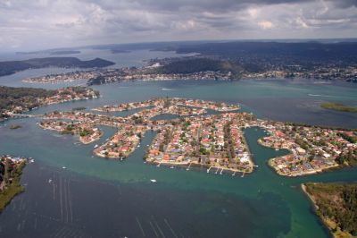
St Huberts Island is a canal estate and suburb of the Central Coast region of New South Wales, Australia connected to the mainland at Daleys Point. It is part of the Central Coast Council local government area.
Map of St Huberts Island NSW 2257, Australia
The modern-day development of St Huberts Island happened when Hooker-Rex Developments (now LJ Hooker Realty) built residential developments on the site in the early-1970s (http://www.gosford.nsw.gov.au/library/local_history/Suburbs/documents/davistown-a-brief-history)
References
St Huberts Island, New South Wales Wikipedia(Text) CC BY-SA