
OS grid reference SP525060 Sovereign state United Kingdom Dialling code 01865 | Civil parish unparished District Oxford | |
 | ||
St Clement's is a district in Oxford, England, on the east bank of the River Cherwell. Its main road, St Clement's Street (often shortened to just "St Clement's"), links The Plain (a roundabout) near Magdalen Bridge with London Place at the foot of Headington Hill at the junction with Marston Road to the north.
The road continues east as Headington Road and is designated the A420. At the point where St Clement's reaches South Park, there is a junction with Morrell Avenue to the southwest. There are several restaurants in the street.
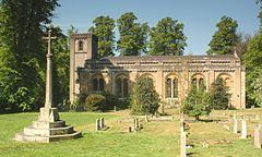
St Clement's Church, the area's Church of England parish church, is off the southern end of Marston Road. The original St Clement's parish church was at The Plain but was demolished in 1828.
Stone's Almshouses in St Clement's Street were founded in 1700.
The artist William Turner lived here with his wife Elizabeth Ilott after their marriage in 1824.
The Royal Microscopical Society, a learned society for the promotion of microscopy, has been based on St Clement's Street since 1967.