
Population 69 Local time Friday 1:28 AM UK parliament constituency North East Somerset | OS grid reference ST778704 Sovereign state United Kingdom Built 12th century | |
 | ||
Weather 12°C, Wind S at 6 km/h, 82% Humidity | ||
St Catherine is a small village within the civil parish of Batheaston in the Bath and North East Somerset unitary authority, Somerset, England, United Kingdom. The parish has a population of 69.
Contents
Map of Saint Catherine, UK
History
St Catherine was part of the hundred of Bath Forum.
Governance
The parish council has responsibility for local issues, including setting an annual precept (local rate) to cover the council’s operating costs and producing annual accounts for public scrutiny. The parish council evaluates local planning applications and works with the local police, district council officers, and neighbourhood watch groups on matters of crime, security, and traffic. The parish council's role also includes initiating projects for the maintenance and repair of parish facilities, such as the village hall or community centre, playing fields and playgrounds, as well as consulting with the district council on the maintenance, repair, and improvement of highways, drainage, footpaths, public transport, and street cleaning. Conservation matters (including trees and listed buildings) and environmental issues are also of interest to the council.
The parish falls within the unitary authority of Bath and North East Somerset, created in 1996. Before 1974 the parish was part of the Bathavon Rural District.
The parish is part of the North East Somerset Parliamentary constituency. It is also part of the South West England constituency of the European Parliament.
Religious sites
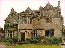
St Catherine's church was built in the 12th century as a chapel-of-ease of Bath. It is a Grade II* listed building. It stands within the grounds of the 16th century St Catherine's Court, which is Grade I listed.