
- elevation 4,325 ft (1,318 m) - average 580 cu ft/s (16 m/s) Discharge 16.42 m³/s | - elevation 4,163 ft (1,269 m) Basin area 4,053 km² Basin area 4,053 km² | |
 | ||
- max 14,900 cu ft/s (422 m/s) | ||
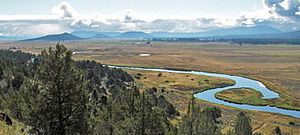
The Sprague River is a tributary of the Williamson River, approximately 75 miles (121 km) long, in southwestern Oregon in the United States. It drains an arid volcanic plateau region east of the Cascade Range in the watershed of the Klamath River.
Map of Sprague River, Oregon, USA
It is formed by the confluence of its north and south forks in eastern Klamath County, approximately 35 miles (56 km) east-northeast of Klamath Falls at 42.437650°N 121.109435°W / 42.437650; -121.109435 (Sprague River source). The North Fork Sprague River, 30 miles (48 km), rises in southwestern Lake County in the Fremont National Forest near Gearhart Mountain at 42.5287618°N 120.8183115°W / 42.5287618; -120.8183115 (North Fork Sprague River source) and flows southwest. The South Fork Sprague River, 30 miles (48 km), rises northeast of Quartz Mountain Pass at 42.4815400°N 120.7869201°W / 42.4815400; -120.7869201 (South Fork Sprague River source) and flows west-northwest. The combined stream flows west through the broad Sprague Valley, past the small communities of Bly, Beatty, and Sprague River. It joins the Williamson from the east at Chiloquin, about 10 miles (16 km) north of the mouth of the Williamson on Upper Klamath Lake at 42.5712475°N 121.8744593°W / 42.5712475; -121.8744593 (Sprague River mouth).
It receives the Sycan River from the north at Beatty. Superb trout fishing exists in the Sprague and its tributaries.