
Type Street Suburb(s) Melbourne CBD Via Melbourne | Route number(s) State Route 50 Length 2 km Major cities Melbourne | |
 | ||
NW end Dynon Road and Dryburgh Street, West Melbourne SE end Whiteman Street and Normanby Road, Southbank | ||
4502 220 spencer street melbourne ray white melbourne cbd
Spencer Street is a major street and thoroughfare in the central business district of Melbourne, Australia. The street was gazetted in 1837 as the western-most boundary of the Hoddle Grid.
Contents
- 4502 220 spencer street melbourne ray white melbourne cbd
- Map of Spencer St Victoria Australia
- Location
- History
- Notable Buildings
- Heritage Listed
- Other Buildings
- Under Construction
- Transport
- References
Map of Spencer St, Victoria, Australia
Spencer Street is named for John Spencer, 3rd Earl Spencer, former Chancellor of the Exchequer under Lord Melbourne, Prime Minister of the United Kingdom.
Location
Running roughly north-south, Spencer Street forms the western edge of the original Hoddle Grid. To the north Spencer Street becomes Dynon Road, whilst to the south it becomes Clarendon Street after crossing the Spencer Street Bridge over the Yarra River.
Spencer Street denotes the boundary between Melbourne and Docklands to the west, West Melbourne in the north and Southbank in the south, near Batman Park.
History
Spencer Street was the site of the first permanent buildings in the settlement now called Melbourne. The home of John Batman was built on nearby Batman's Hill where he lived until his death and the early camps of Captain William Lonsdale and Charles La Trobe were located along the street.
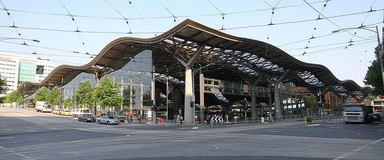
With the creation of Melbourne Docklands in 2000, the construction of Southern Cross railway station in 2006 and the addition of a shopping centre, the area has undergone significant urban renewal.
Notable Buildings
Many buildings and structures on Spencer Street are listed on the Victorian Heritage Register and/or classified by the National Trust of Australia. Others are more modern and significant for their current or future function. These include:
Heritage Listed
Other Buildings
Under Construction
Several apartment buildings and hotels are currently under construction, including the Ritz-Carlton which will be Australia's tallest hotel when completed.
Victoria's largest police station, the City West Police Centre, is located on Spencer Street. The Victoria Police Centre is set to open adjacent to it on Spencer Street as the new headquarters for Victoria Police in 2020.
Transport
Spencer Street is served primarily by the Southern Cross railway station and is both a major terminus for V/Line regional passenger trains and a major stop for metropolitan trains. The street is served by tram routes 11, 12, 35, 96 and 109 at its southern end and 30, 75 and 86 towards the north.