Time zone CET/CEST (UTC+1/+2) Area 56.63 km² Population 746 (31 Dec 2008) Dialling code 039727 | Elevation 17 m (56 ft) Postal codes 17392 Local time Wednesday 3:26 AM Postal code 17392 | |
 | ||
Weather 6°C, Wind SW at 10 km/h, 81% Humidity | ||
Spantekow is a municipality in the Vorpommern-Greifswald district, in Mecklenburg-Vorpommern, Germany. It comprises the villages Dennin, Drewelow, Fasanenhof, Janow, Japenzin, Neuendorf B, Rehberg, Rebelow and Spantekow.
Map of Spantekow, Germany
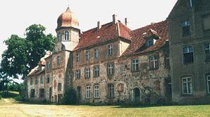
Since the Middle Ages, Spantekow is a local administrative center and the site of a fortress. Though Spantekow castle was largely destroyed in a Brandenburgian attack in 1677, it remained a residence of the local nobility until 1945. Today, the village is seat of the Amt Anklam-Land.
References
Spantekow Wikipedia(Text) CC BY-SA
