
 | ||
Southport is a community in the Canadian province of Newfoundland and Labrador, located on the southern side of the entrance to Trinity Bay's Southwest Arm, about 41 km southeast of Clarenville. Its latitude and longitude are 48°02'59"N, 53°37'59"W.
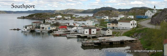
Southport had a very small population of 95 in 2001. The population has dropped a lot since the early 1990s because a lot of families have moved away to find work. Southport currently has no businesses, the only store, Avery's Grocery, closed in 2001 due to poor business.
This snug harbour (one of the most photographed in the province) attracted early settlement because of its location near fishing grounds around West Random Head and the entrance to Southwest Arm. The harbour also had the advantage of being easily defended: the earliest settlers likely had their fishing premises on Fox Harbour Island. The 1753 Census of Trinity Bay indicated five households on Fox [Harbour] Island and another three in "Harts Eas".
History
The harbour was used as an alternative anchorage by 17th century English ships, fishing out of nearby Heart's Ease. Heart's Ease was settled by the late 18th century by the Baker family, who were also the first known family of Southport. Thomas Baker was living in Southport in the early 19th century and was recorded there on the 1836 voters' list. In that year the Census recorded two families and a total population of 11. Soon thereafter the family name Baker disappeared from Southport, and was replaced by an influx of settlers from the Grates Cove area, on the opposite side of Trinity Bay. The first permanent settlers of Southport were James Dean (1802–1865) of Old Perlican, James Lambert, and Joseph Martin of Grates Cove. These families may have begun winter woods work in Southwest Arm in the 1830s and moved to Southport in the 1840s and 1850s. In about 1870 these early families were joined by Thomas Smith, from Conception Bay. Other surnames of Southport have included Avery, Button, Ivany, Hiscock, Langer, Miller, Pelley, Pond, Seaward, Balsom and White.
The 1845 Census shows a population of 38, increasing to 102 by 1857 (but this figure likely includes Gooseberry Cove). Southport and Gooseberry Cove, separated by a neck of land only 1 km wide, shared schools and churches: a Church of England school/chapel was located in Gooseberry Cove (as was St. Alban's church in later years), while at Southport the first Methodist school/chapel was built in 1869. James Dean was active as a lay reader in establishing the Methodist church at Southport and elsewhere in the Random area. Eventually there were separate school and church buildings of each denomination frequented by people from both communities.
The early settlers were inshore fishing families, but the community also became involved in the Labrador fishery in the 1870s. Early residents traded most catches with merchants in Trinity, but by the 19th century Hickman's Harbour had become the local mercantile centre. In the 1880s Captain Edmund Seaward operated at least one banking schooner and several Labrador schooners from Southport. Early in the 20th century small merchants began trading into Southwest Arm from Southport (notably Kenneth Smith) and had several Labrador and coasting schooners built in the area, with the Lamberts being the best known shipwrights. Families also continued the tradition of wintering in tilts at a variety of sites in Southwest Arm and Random Sound. Although most seasonal sawmilling work was carried out elsewhere, there was also a small local mill at Muddy Pond and a cooperage mill on Fox Harbour Island (where the Pond family were resident until the late 19th century). Early in the 20th century, with the establishment of the Grand Falls pulp and paper mill, Southport fishermen drew upon this tradition of woods work to find seasonal employment cutting pulpwood. As the Labrador fishery declined in the early 20th century, the tradition of working away from the community for much of the year continued, with the emphasis being on woods work and general construction labour. By 1956, when Southport received its first road connection with the Province's highway system, the population of the community had topped 200. By this time, however, the Labrador fishery had died and most fishing was carried out in local waters, for cod and lobster. Fishermen began selling their catches fresh, while a few acquired longliners in the early 1960s, after a small fish plant opened at Gooseberry Cove. Southport became one of the principal centres in Newfoundland for the production of salted or pickled turbot and also developed a mackerel bar seine fishery in the 1960s, with much of this product being pickled and sold to West Indian markets. However, some left the fishery altogether, finding wage labour at Come by Chance or in the Clarenville area—which had an increasing role as a regional service centre as highways were upgraded. Improved roads also made it possible for students from Southport to be bused to an integrated central school at Little Heart's Ease. From the late 1970s a number of families erected homes on the road between Southport and Gooseberry Cove, while others moved to Clarenville. As of 2007, there are less than 50 inhabitants as a large number of people have moved to mainland Canada, namely Ontario and Alberta.