
- elevation 5,775 ft (1,760 m) Length 61 km | - elevation 4,998 ft (1,523 m) | |
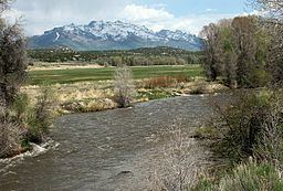 | ||
The South Fork of the Humboldt River has its origins in a fan-shaped group of canyons draining the western slopes of the Ruby Mountains in northeastern Nevada. These headwaters run from Ruby Dome south to King Peak, and include Echo, Box, Kleckner, North Furlong, Long, Segunda, Drown, and Rattlesnake Canyons. Streams draining these canyons exit the mountains and converge at an elevation of 5,775 feet (1,760 m), near the town of Lee and within the tribal lands of the Te-Moak tribe of the South Fork Band of the Western Shoshone.
Map of South Fork Humboldt River, Nevada, USA
Continuing its northwest course, the river merges with the flow of Huntington Creek, passes through the historic area of Twin Bridges, and then enters the more recent South Fork Reservoir, State Park, and South Fork Dam dating from 1988. It then passes though South Fork Canyon, where it merges with the flows of Ten-mile and Dixie Creeks. It was here that on September 25, 1846 the Donner Party wagon train completed the segment of their journey on the Hastings Cutoff, and rejoined the original California Trail.
After an estimated total of 38 miles (61 km), the South Fork flows into the main branch of the Humboldt River at approximately 40°46.3′N 115°53.3′W and at an elevation of 4,998 feet (1,523 m), about 7 miles (11 km) southwest of the city of Elko.