
Time zone Mountain (MST) (UTC-7) Elevation 2,502 m Population 372 (2013) | Incorporated May 19, 1992 Area code(s) 719 Zip code 81154 Local time Monday 6:08 PM | |
 | ||
Weather 9°C, Wind S at 16 km/h, 45% Humidity | ||
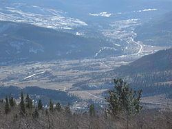
South Fork is a statutory town in Rio Grande County, Colorado, United States. It lies at the confluence of the South Fork and Rio Grande rivers. The population was 604 at the 2000 census.
Contents
Map of South Fork, CO 81154, USA
Geography
South Fork is located at 37°40′09″N 106°38′34″W.
According to the United States Census Bureau, the town has a total area of 2.4 square miles (6.2 km2), all land.
History
South Fork was once the site of timber milling operations.
South Fork was founded in 1882, by which date its location was already marked by the presence of a coaching post dating from the construction of the railroad connection of the Rio Grande Western Railroad line to Creede which had been built to support the Creede silver mine. It was only in 1992 that South Fork achieved independent statutory town status, making it the youngest statutory town in the state. Originally the principal economic activities involved forestry and mining, but in recent decades these have been overtaken in the employment statistics by tourism.
On June 21, 2013, a wildfire burning 6 miles (9.7 km) from the town prompted mandatory evacuations for all South Fork residents. Firefighters initially said the fire would likely consume the town. In subsequent days it was reported that the town probably would not burn, although the fire came as close as 1.5 miles (2.4 km) from the town.
Demographics
South Fork has about 600 permanent residents, but a substantially larger summer population due to seasonal residents and visitors.
As of the census of 2000, there were 604 people, 274 households, and 187 families residing in the town. The population density was 255.2 people per square mile (98.4/km²). There were 580 housing units at an average density of 245.1 per square mile (94.5/km²). The racial makeup of the town was 92.88% White, 0.17% African American, 0.33% Native American, 0.17% Asian, 2.98% from other races, and 3.48% from two or more races. Hispanic or Latino of any race were 12.42% of the population.
There were 274 households out of which 25.5% had children under the age of 18 living with them, 58.0% were married couples living together, 8.8% had a female householder with no husband present, and 31.4% were non-families. 27.7% of all households were made up of individuals and 7.3% had someone living alone who was 65 years of age or older. The average household size was 2.20 and the average family size was 2.63.
In the town, the population was spread out with 21.7% under the age of 18, 7.1% from 18 to 24, 24.5% from 25 to 44, 29.1% from 45 to 64, and 17.5% who were 65 years of age or older. The median age was 43 years. For every 100 females there were 96.1 males. For every 100 females age 18 and over, there were 99.6 males.
The median income for a household in the town was $36,667, and the median income for a family was $45,417. Males had a median income of $32,188 versus $19,063 for females. The per capita income for the town was $26,128. About 4.1% of families and 6.1% of the population were below the poverty line, including 6.7% of those under age 18 and 1.6% of those age 65 or over.