
Division A (IRT), B (BMT) Opened 16 March 2009 Borough Manhattan | Rank 40 out of 425 Phone +1 877-690-5116 | |
 | ||
Line BMT Broadway Line
IRT Broadway–Seventh Avenue Line Services 1 (all times)
N (late nights)
R (all times)
W (weekdays only) Transit connections MTA-NYCT Bus: M15, M15 SBS, M20, M55
Staten Island Ferry at Whitehall Terminal Passengers (2015) 8,750,364 (station complex) 23% Address New York, NY 10004, United States Locale Battery Park, Financial District Similar Bowling Green, Staten Island Ferry, Staten Island Ferry Whi, Times Square–42nd Street/Por, Cortlandt Street | ||
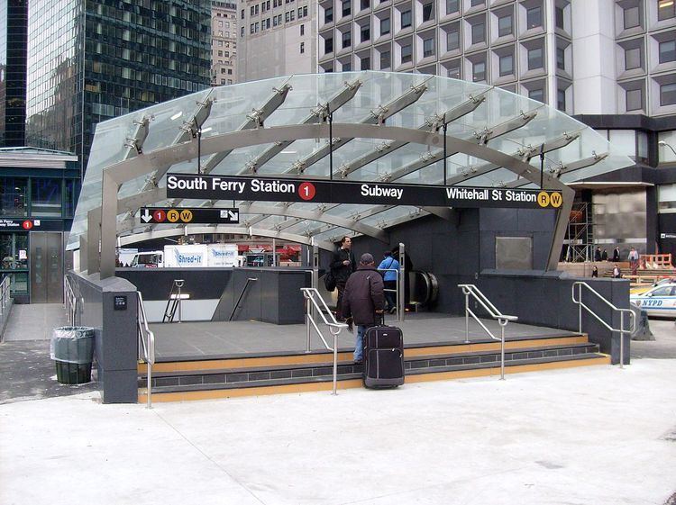
South Ferry–Whitehall Street is a New York City Subway station complex in the Manhattan neighborhood of Financial District, under Battery Park. The complex is shared by the IRT Broadway–Seventh Avenue Line and the BMT Broadway Line. It is served by the:
Contents
- Exits
- IRT BroadwaySeventh Avenue Line platforms
- Old South Ferry station loop platforms 19052009 2013present
- Outer platform
- Inner platform
- New South Ferry station 20092012
- Construction
- Post Hurricane Sandy closure
- Gallery
- BMT Broadway Line platforms
- Notable places nearby
- References
The 2009 completion of the new South Ferry IRT terminal consolidated the two formerly unconnected stations, adding a free transfer between the 1 and the N, R, and W trains at the older Whitehall Street station. In 2013, the MTA also added a connection to the old South Ferry station while the new station was closed.
This station complex is the third on the site to bear the name South Ferry. The second, opened from 1905 to 2009, was a double Balloon loop that served the IRT Broadway–Seventh Avenue and IRT Lexington Avenue Lines. The outer loop was replaced by a newer station in 2009, but reopened to replace its successor in 2013. The first was an elevated station opened from 1877 to 1950, and served the former IRT Ninth, Sixth, Third, and Second Avenue lines.
Exits
Entrances and exits are located at the following places:
IRT Broadway–Seventh Avenue Line platforms
There are two separate stations on the IRT Broadway–Seventh Avenue Line, which are individually named South Ferry due to their connection to Manhattan's South Ferry. The name "South Ferry loops" is used for the Old South Ferry platforms, while the newer platforms are called "New South Ferry." The newer island platform station was used by the Broadway–Seventh Avenue Line's 1 service from 2009 to 2012 until it was damaged by Hurricane Sandy. The outer loop platform reopened on April 4, 2013, to provide temporary replacement service.
Old South Ferry station loop platforms (1905–2009, 2013–present)
The South Ferry loops consist of two side platforms on curved balloon loop tracks, of which only the outer one is operational; the inner one is walled off. However, free transfers were unavailable between the platforms and each platform was meant to be served by its own line. The most recent configuration using both tracks consisted of the IRT Broadway–Seventh Avenue Line on the outer loop platform and the IRT Lexington Avenue Line on the inner loop platform.
Outer platform
On July 10, 1905, the outer South Ferry platform was the first of the two platforms to open and was an extension of the original trunk line of the Interborough Rapid Transit Company. The inner track existed when the station was built, but only as a storage track. When the "H" system of the IRT opened on July 1, 1918, Broadway–Seventh Avenue Line trains used the outer platform while the inner platform was opened for IRT Lexington Avenue Line trains which used the original trunk line in Lower Manhattan.
Services on the Broadway–Seventh Avenue Line, including the 1 and 9 trains (the latter of which was a rush-hour skip-stop duplicate of the former from 1989–2005), have used the outer platform as a terminal station since its inception, except for two relatively short periods of time. The first period was between September 2001 and September 2002 since the main branch south of Chambers Street was impassable after the September 11 attacks. The second was from March 16, 2009, when the new South Ferry station opened for 1 train passengers, to April 4, 2013, when the outer platform reopened with a transfer to the BMT section of the station complex. The newer station, located underneath this one, allowed a free transfer to the BMT station whereas neither of this station's platforms originally did.
Station features
The outer platform serves 1 trains at all times and is the station's only operational platform. The platform is smaller than most others in the system, having only 16,800 square feet (1,560 m2) of surface area, and it was originally served from two stairs leading from the Staten Island Ferry Whitehall Terminal. The radius of the curve is only 190 feet (58 m), meaning that the platform curves approximately 77.5 degrees between its front and back ends. The platform accommodates the first five cars of a train, but the rear five cars of a 10-car 1 train cannot load or unload. In addition, spray nozzles are required to lubricate the track to reduce the friction caused by the tight curve, which slows train operation and generates a loud metallic scraping noise.
Because of the curve, gap fillers were required, and are still used, to bridge the gap between the platform and the doors. The now-automated gap fillers previously required manual operation, with a foreman and at least two train crew, all of who could directly see each other; the train crew had to give a signal to the foreman, who pulled a 4 to 5 feet (1.2 to 1.5 m) tall wooden lever to manually extend and retract the gap fillers. The gap fillers are also unreliable, as they need 15 days of maintenance for every 6 months in service.
The platform featured an oak ticket booth and an oak-cased clock from the Self-Winding Clock Company of New York. Evidence of the now-demolished ticket booth is a Beaux Arts design engraved on the ceiling. The platform also features station tiling by Heins & LaFarge, who designed the station plaque in a sans-serif font. The walls are made of small white rectangular tiles, except for the bottom 3 feet (0.91 m), which is marble. There are also fifteen ceramic plaques toward the top of the platform wall, all of which depict a sloop in the New York Harbor to signify the station's location and use. The top of the wall also includes festooned garlands and station monograms, in addition to ceramic trim where the wall intersects the ceiling. The station artwork on the original exit's landing is a 1990 mural, "South Sails", by former MTA Arts & Design director Sandra Bloodworth. During the 2004 Finding Of No Significant Impact (FONSI) for the station, it was determined that the station was eligible for National Register of Historic Places status.
Replacement and restoration
The South Ferry loop station proved to be a service bottleneck. Operationally, the loop station functioned an intermediate station rather than as a true terminal, as trains would simply proceed back to Rector Street without the conductor needing to go to the reverse end of the train. Additionally, unlike most terminal stations in the system, there were neither layup tracks nor an additional track to store terminating trains, and there were no additional layup tracks along the line until at least 34th Street–Penn Station. This meant that trains could not dwell at the station for longer for 90 seconds (including the 5 to 10 seconds each that it took to extend and retract the gap fillers). Any trains that went out of passenger service at the station could caused major delays along the rest of the line. Finally, trains could only proceed through the station at slow speeds, adding 30 to 60 seconds to travel time compared to a "regular" terminal station with two tracks and a full-length platform. This ensured that 1 trains were delayed at the Chambers Street station, three stops north, for up to two minutes in both directions.
In order to eliminate this special operation, the new station was built as a two-track, 10-car-long island platform on a less severe curve, permitting the operation of a typical terminal station. The MTA stated that the new station saved four to six minutes of a passenger's trip time and increased the peak capacity of the 1 service to 24 trains per hour (or one every 2 minutes 30 seconds), as opposed to 16 to 17 trains per hour (or one every 4 minutes) with the loop station. The successor station is fully accessible (although its transfer to the BMT Broadway Line is not), with the main entrance located across from the Staten Island Ferry terminal building's entrance.
After Hurricane Sandy in late October 2012, the outer loop was brought back into service in order to turn trains uptown after terminating at Rector Street, since the replacement station suffered extensive flooding damage and closed for repairs; the station is expected to reopen in the summer of 2017. After a few months, the MTA decided to reopen the loop station as an interim terminal to restore the connection from 1 service to the Staten Island Ferry. The station reopened on April 4, 2013, with a connection to Whitehall Street.
Inner platform
The inner platform opened for IRT Lexington Avenue Line passengers on July 1, 1918, as that line's service was moved from the outer platform. This platform has an even sharper curve than the outer platform, and only the center doors opened here, with special arched openings in a wall between the platform and track at the locations of the doors.
In the late 1950s, when the IRT division began to use mostly R-type cars which could not have only the center doors opened, 5 trains (which ended at South Ferry evenings and weekends only) and 6 trains (which ended at South Ferry late nights) were rerouted to the outer loop. The Bowling Green–South Ferry shuttle, which ran weekdays and at first also late nights, continued to use the inner loop, running to the west platform at Bowling Green until 1977, when the inner platform was closed and Lexington Avenue trains stopped using the outer loop. Specially modified R12 cars were used starting in the late 1960s until the service ended. These cars had two different door controls; the first opened the outer two sets of doors while the second opened the center set of doors only. There was no free transfer between the inner loop and the outer loop platforms.
The inner track is used to turn 5 trains when they terminate at Bowling Green on weekday evenings and weekends.
New South Ferry station (2009–2012)
The South Ferry station, which serves the IRT Broadway–Seventh Avenue Line exclusively, has two tracks and one island platform. The two tracks end at bumper blocks at the south end of the platform. This station was built as a replacement for the loop station, which was relegated to being used for turn-arounds once the new station opened. Unlike the loop station, this station only can access IRT Broadway–Seventh Avenue Line local trains, and does not connect with the Lexington Avenue Line. It allows 24 trains per hour (or one every 2 minutes and 30 seconds) to terminate at the station.
The new station offers three street entrances, with the main entrance located across from the Staten Island Ferry terminal; the loop station originally had only one entrance within the terminal itself before it reopened with a connection to the South Ferry–Whitehall Street complex in 2013. It also added a free transfer to the Whitehall Street–South Ferry station on the BMT Broadway Line. Landscaping for Peter Minuit Plaza was completed in May 2010.
Construction
On September 11, 2001, a terrorist attack destroyed the World Trade Center, located slightly to the north of South Ferry and the Battery. Since the entire WTC site was destroyed in the attacks, this meant that the segment of the IRT Broadway–Seventh Avenue Line that ran through the WTC, including the Cortlandt Street station two stops north of South Ferry, was also destroyed. This changed 1, 2 and 3 service and led to reduced service in Manhattan and Brooklyn until the WTC section of the line reopened in September 2002. Concurrent with the rebuilding of that section of the line, MTA officials recognized the need to build a more efficient terminal for the 1 and 9 trains at South Ferry, since it was anticipated that the line would be heavily used in the long-term aftermath of the attacks. This also coincided with the renovation of Battery Park.
In 2003, money was allocated for the new station's construction, and in 2005, construction commenced on the new station. The station was originally budgeted at $400 million, with most of the money being a grant from the Federal Transit Administration earmarked for World Trade Center reconstruction. Initially, the station's construction had been opposed because of the high cost and low perceived time savings. However, the FTA issued a Finding of No Significant Impact on August 30, 2004, and the South Ferry Terminal Project was allowed to proceed. During planning, the FTA evaluated several alternatives, including extending the existing loop platform northward; building the terminal with an extra track and platform; building a two-track terminal underneath the loop; building a two-track terminal directly under Water Street, to the east; building a two-track terminal along the waterfront under South Street, to the southeast; building a three-track terminal below the BMT Broadway Line's Whitehall Street station, under the namesake street; and building the terminal diagonally under Peter Minuit Plaza. Of these seven options, the last one was chosen because any other alternative would have been either too expensive or logistically infeasible.
The project was split up into three parts: construction of bellmouths, a fan plant, and track junctions from the existing line; approach tunnels to the station; and the station itself. The bellmouths' construction would require that 270 feet (82 m) of the original tunnel would have to be rebuilt to accommodate the new junction. The fan plant, located to the east of the existing line, would facilitate ventilation from the new deep-level station, which would be located below three exiting subway lines (the loop platform, the IRT Lexington Avenue Line's Joralemon Street Tunnel, and the BMT Broadway Line's Montague Street Tunnel). The two new approach tunnels would be single-track tunnels connecting to a cavern where a double crossover switch would be installed. The new 76,820-square-foot (7,137 m2) station, located at a depth of 50 feet (15 m), would contain a 600-by-25-foot (182.9 by 7.6 m) platform, a new mezzanine level, escalators, and an elevator.
On December 8, 2005, New York City authorities announced that builders working on the new station had found the remains of a 200-year-old stone wall. After archaeological analysis, it was widely reported to be the oldest man-made structure still in place in Manhattan. Four walls and over 250,000 individual artifacts were found in the excavation of this subway station. A portion of one wall was placed on temporary display inside Castle Clinton.
On December 11, 2008, news sources reported that the new station was essentially finished. In January 2009, however, the opening was delayed because the tracks were too far from the edge of the platform, and the gap between the platform and the train did not meet ADA standards. Other delays were attributed to leaks in the station, which were caused by the station's high water table. The problem was corrected and the station opened on March 16, 2009, a year behind when it was originally set to open. At $530 million, the new South Ferry station ended up being $130 million over budget. It was the first new subway station completed since 1989 when the IND 63rd Street Line stations opened. On April 16, 2009, MTA Capital Construction awarded a $19.2 million contract to Tully Construction Company to reconstruct Peter Minuit Plaza, which is above the station.
After the station opened, a long portion of the excavated historic wall was embedded permanently into the wall of the entrance to the newly constructed station. "This wall most likely is a portion of the gun batteries that once protected the city in the late 17th and 18th centuries and gave rise to the modern park name," said Robert Tierney, chairman of the New York City Landmarks Preservation Commission. The city and the New York City Transit Authority plan to work together to preserve the remains, which were described as "an important remnant of the history of New York City."
The station's mezzanine and escalator shafts feature monumental artwork titled See it split, see it change, which consists of fused glass wall, stone mosaic, and a stainless steel fence. The artwork, by Doug and Mike Starn, depicts Manhattan topography and was installed in the mezzanine over a period of three years. At the time of the work's installation, it was the most expensive MTA Arts for Transit work ever installed, with a price tag of $1 million.
Post-Hurricane Sandy closure
On October 29, 2012, the new South Ferry station suffered extensive flooding damage caused by Hurricane Sandy. The station was flooded in up to 80 feet (24 m) of salt water, submerging it from the track level to the mezzanine, and turned the station into a "large fish tank," as then-MTA chairman Joseph Lhota described it. As a result, this section of the complex was closed until further notice. The MTA estimated that repairs would cost $600 million and might continue until 2016. The terminal for the routes serving the station was moved back to Rector Street until the old loop station could be put back into service. The old loop station reopened on April 4, 2013, as a temporary replacement until the new station is restored to revenue service. The connection between the loop station and the rest of the station necessitated the temporary removal of a 20-foot (6.1 m) section of the See it split, see it change artwork.
The station is expected to reopen in the summer of 2017 after renovations, signal room relocations, and extensive waterproofing work. The signal room itself could be delayed until 2019. The $194 million contract was awarded on December 8, 2014, and the station is currently undergoing extensive reconstruction, including the installation of retractable floodgates at exits and entrances; sealing vents, manholes, hatches, conduits, and ducts; and cleaning up the station. The renovation itself costs $345 million. These improvements necessitated the closure of the station complex's main entrance for almost a year starting in October 2015. After four and a half years of reconstruction, the new station is slated to reopen in summer 2017.
Gallery
BMT Broadway Line platforms
Whitehall Street–South Ferry on the BMT Broadway Line has three tracks and two island platforms. The outer tracks continue south into the Montague Street Tunnel to the BMT Fourth Avenue Line in Brooklyn, and are used by late-night N trains and daytime R trains. The center track, used to terminate late-night R trains from Brooklyn and weekday W trains from Queens, merges with the outer tracks at either end of the station.
The station is rather deep. This is because of two factors, the line goes under the East River directly southeast of the station, and the station exists just south of the shallower Bowling Green station. The fare control area and transfer to the IRT Broadway–Seventh Avenue Line platforms are at the extreme south end of the station, with additional exits at the north end. Both platforms are approximately 12–15 feet (3.7–4.6 m) wide, enough to fit several narrow stairways along the platform's length, making it too narrow to safely install elevators to the platforms.
South of this station, a pair of bellmouths exists, allowing for a connection to a never-built East River tunnel south of the Montague Street Tunnel, going towards the proposed DeKalb Avenue bypass, using the old LIRR Atlantic Avenue Tunnel or under another street in Brooklyn. Further south is a flying junction joining from Broad Street on the BMT Nassau Street Line (no regular service; the last service to use these tracks was the M, rerouted in 2010). Also south of this station, the emergency exit from the Montague Street Tunnel is located in the Nassau Street Connection which means before the Nassau Street Line was built, the emergency exit was actually in the bellmouth for the proposed line. The bellmouth was visible for years until it was used by the Nassau Street Connection when the entire line opened in 1931.
When this station opened on September 20, 1918, it was the terminal for the Broadway Line. The connection to Brooklyn opened on August 1, 1920.
On January 6, 1994, Automated Fare Collection turnstiles went into service at this station, and at the Wall Street station.