
Intercommunality Coteaux de la Braye Area 16.88 km² | Canton Savigny-sur-Braye Population (1999) 437 Local time Monday 1:01 PM | |
 | ||
Weather 17°C, Wind E at 16 km/h, 54% Humidity | ||
Sougé is a commune of the Loir-et-Cher department in central France.
Contents
Map of 41800 Soug%C3%A9, France
It is situated on the Loir River in the Loir Valley, in the Centre region of France. The nearest town of more than 40,000 inhabitants is Tours.
History
In the time of the Romans, Sougé had a special importance because of his Roman's camp, called "Camp of Cesar" in the country. Today the fortifications are not visible any longer, but they were visible in the last century.
Geography
Sougé is a village in the department of Loir-et-Cher, there is 437 inhabitants. The village of Sougé is near the village of Couture-sur-Loir (the village of Pierre de Ronsard). The village of Sougé is near the town of Montoire-sur-le-Loir.
Name
Sougé was called Silviacus (3rd and 8th century), then Selgiacus (11th century), Sugeium in 1216, Sougeium in the 13th century, paroisse des Roches de Sougé in 1595, Sougé-sur-Loir in 1675, Sougé-sur-Braye after the French Revolution, and now Sougé.
Monuments
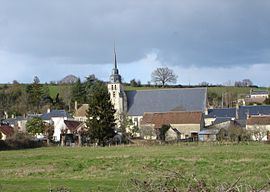
The spacious church of St. Quintin has a barrel-vaulted roof and early twentieth century glass depicting amongst other themes Pope Leo XIII. There are traces of Renaissance architecture along the main (and almost only) street. The village cemetery contains Commonwealth graves.