
Last eruption 1240 ± 50 years | Mountain type Caldera Elevation 2,282 m Parent range Andes | |
 | ||
Volcanic arc/belt Southern Volcanic Zone of the Andes Similar Quetrupillán, Lonquimay, Carrán‑Los Venados, Irruputuncu, Llaima | ||
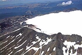
Sollipulli is an ice-filled volcanic caldera, which lies about 12 kilometres south of the small town of Melipeuco in the La Araucanía Region, Chile. Volcan Sollipulli lies northeast of Caburgua Lake and southeast of Llaima volcano; and there are views to at least seven active volcanoes from the summit rim. The volcano has evolved in close contact with glacial ice and has some typical subglacial volcanic features such as hyaloclastite breccia and pillow lava. It differs from many calderas in that Sollipulli appears to have collapsed in a non-explosive manner. The age of collapse is not yet known, but since the caldera formed, volcanic activity has continued along the surrounding ring faults which have produced lava flows and lava domes, increasing the elevation of the caldera wall. The caldera is 4 km in average diameter and according to ground penetrating radar measurements made in 1993 it contained a maximum ice thickness of at least 550 m, but perhaps as much as 650 m, at that time.
Map of Sollipulli, Melipeuco, Araucania, Chile
The volcanic complex is located within the boundaries of the sector Hualalafquén of Villarrica National Reserve.