
Mountain range Krkonoše | Elevation 1,489 m Parent range Krkonoše | |
 | ||
Easiest route public path marked red from Przełęcz Karkonoska Similar Mały Szyszak, Czarna Kopa, Śląskie Kamienie, Wielki Szyszak, Kleines Rad | ||
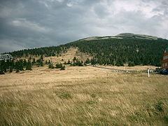
Smogornia (Czech Stříbrný hřbet, German Mittagsberg, 1469 m a.s.l.) - peak in the Karkonosze Mountains on Polish and Czech border. It is situated in the eastern part of the main range. The peak is not accessible; the main Sudetes trail and Polish - Czech Friendship Trail traverses the mountain ca 300 m north from the peak. On the northern slope of the mountain there is a glacial cirque. The mountain has mild slopes, mostly deforested, covered in mountain pine.
Map of Smogornia
References
Smogornia Wikipedia(Text) CC BY-SA