
 | ||
Points of interest Verdmont, Spittal Pond Nature Reserve, Pink Beach - East Beach, John Smith's Bay, Pink Beach - West Beach | ||
Bermuda drive south road hamilton and smith s parish
Smith's Parish is one of the nine parishes of Bermuda. It is named for English aristocrat Sir Thomas Smith/Smythe (1558-1625).
Contents
- Bermuda drive south road hamilton and smith s parish
- Map of Smiths Parish Bermuda
- Spanish grange in smith s parish
- Description
- History
- Politics
- Education
- References
Map of Smiths Parish, Bermuda
Spanish grange in smith s parish
Description
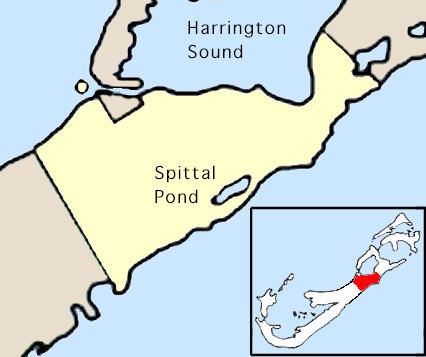
It is located in the northeast of the main island, at the southern end of Harrington Sound, the large lagoon close to the main island's northeastern tip. It is joined to Devonshire Parish in the southwest and Hamilton Parish in the northeast. As with most of Bermuda's parishes, it covers just over 2.3 square miles (about 6.0 km² or 1500 acres).
Natural features in Smith's include Spittal Pond, John Smith's Beach, Devil's Hole, Gibbet Island, and Spanish Rock.
History
Like all of parishes of Bermuda, Smith's was named after one of the nine chief investors of the Somers Isles (Bermuda) Company. In this case, it was named for the Company's first governor, Sir Thomas Smith, who also acted as a governor for the East India Company and treasurer of the Virginia Company. Smith would go on to invest some £60,000 into Bermuda (only £20,000 less than what he invested in the much larger Virginia). Despite this, his contribution to his stake in the colony was minimal, and the area was briefly known as "Harris' Bay".
Politics
For purposes of national representation, Smith's has been divided into three constituencies (Smith's South, Smith's West and Smith's North), and so has 3 representatives in Parliament. As of 2003, two of these are members of the UBP party, and one is a member of the PLP party.
Education
Schools in the Parish: