
Country United States FIPS code 05-64730 Elevation 37 m Zip code 71762 Population 1,811 (2013) | Time zone Central (CST) (UTC-6) GNIS feature ID 0058637 Area 10.9 km² Local time Friday 6:26 AM Area code 870 | |
 | ||
Weather 19°C, Wind SE at 18 km/h, 78% Humidity | ||
Smackover is a small city in Union County, Arkansas, United States. According to Citydata.com, the 2014 population was at 1,790.
Contents
- Map of Smackover AR 71762 USA
- History
- Smackover Oil Field
- Geography
- Climate
- Demographics
- Education
- Culture
- Notable people
- References
Map of Smackover, AR 71762, USA
History
In 1686, the French settlers called this area "SUMAC COUVERT" which translates to "covered in sumac bushes". This was phonetically Anglicized by the English-speaking settlers to the name "SMACKOVER". Oil was discovered in this area in 1922 which brought national attention and a boom.
Smackover was incorporated in 1923. In the 1920s there was a large scale oil industry in Smackover.
Smackover Oil Field
The Smackover Oil Field was discovered on 14 April 1922. The J.T. Murphy well drilled by Oil Operators Trust, reached the Upper Cretaceous Nacatoch sand at a depth of 2024 feet, part of the Norphlet dome. Within a year, almost 1,000 wells had produced 25 million barrels of oil. In Oct. 1922, a lighter oil was produced further west, from the Meakin sand at depths between 2230 and 2350 feet. Oil was discovered in the Blossom sand at a depth of 2610 feet in March 1923. The Graves sand was produced at a depth of 2501 feet in Jan. 1925. Oil was discovered in the Jurassic Smackover limestone at a depth of 4800 feet on 8 May 1936 by the Phillips Petroleum Co. Oil and gas were produced from the porous Reynolds oolite at a depth of 4897 feet.
Geography
Smackover is located at 33°21′41″N 92°43′40″W (33.361525, -92.727855).
According to the United States Census Bureau, the city has a total area of 4.2 square miles (11 km2), all of it land. Smackover is also an important town in South Arkansas.
Climate
The climate in this area is characterized by hot, humid summers and generally mild to cool winters. According to the Köppen Climate Classification system, Smackover has a humid subtropical climate, abbreviated "Cfa" on climate maps.
Demographics
As of the census of 2000, there were 2,005 people, 794 households, and 565 families residing in the city. The population density was 471.9 people per square mile (182.1/km²). There were 915 housing units at an average density of 215.3 per square mile (83.1/km²). The racial makeup of the city was 72.57% White, 26.28% Black or African American, 0.10% Native American, 0.05% Asian, 0.05% Pacific Islander, and 0.95% from two or more races. 0.25% of the population were Hispanic or Latino of any race.
There were 794 households out of which 31.1% had children under the age of 18 living with them, 52.9% were married couples living together, 15.1% had a female householder with no husband present, and 28.8% were non-families. 27.3% of all households were made up of individuals and 17.8% had someone living alone who was 65 years of age or older. The average household size was 2.46 and the average family size was 2.99.
In the city, the population was spread out with 24.7% under the age of 18, 7.8% from 18 to 24, 24.7% from 25 to 44, 21.7% from 45 to 64, and 21.1% who were 65 years of age or older. The median age was 39 years. For every 100 females there were 92.2 males. For every 100 females age 18 and over, there were 81.3 males.
The median income for a household in the city was $28,807, and the median income for a family was $36,875. Males had a median income of $31,081 versus $19,536 for females. The per capita income for the city was $14,461. About 9.1% of families and 14.7% of the population were below the poverty line, including 18.8% of those under age 18 and 13.0% of those age 65 or over.
Education
Public education for early childhood, elementary and secondary school students is primarily provided by the Smackover School District, which includes:
The school district's athletic emblem is the Battlin' Buckaroos with black and white as the school colors.
Culture
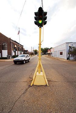
The little oil town of Smackover is steeped in pure Americana, as evidenced by the street-mounted antique stop light in the center of town as well as the old western-style store fronts that line Main Street. It is home to the Arkansas Museum of Natural Resources. The Museum depicts the history and culture of Smackover and the surrounding area with an indoor reconstruction of downtown Smackover, an Oil Field Park, and numerous exhibits illustrating South Arkansas's oil industry. Smackover hosts an annual four-day Oil Town Festival held in June.
With the induction of longtime college coaching legend Wayne Hardin into the NFF College Hall of Fame in 2013, Smackover may have the lead in number of former residents enshrined in the Hall. It now can boast of two natives in the College Football Hall of Fame.