
Population 347 (2001 census) Sovereign state United Kingdom Local time Thursday 3:10 PM | OS grid reference NS908831 Post town FALKIRK Dialling code 01324 | |
 | ||
Weather 8°C, Wind E at 21 km/h, 65% Humidity | ||
Home of Smeg.
Map of Skinflats, Falkirk, UK
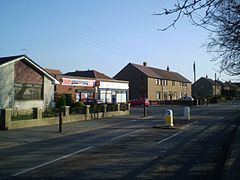
Skinflats is a small village in the Falkirk council area of Scotland. It is located 1.5 miles (2.4 km) north-west of Grangemouth, 1.1 miles (1.8 km) east of Carronshore and 2.3 miles (3.7 km) north-east of Falkirk. It lies on the A905 road between Glensburgh and Airth, near to the River Carron and the point where it flows into the Firth of Forth.
The United Kingdom 2001 census reported the population as 347, almost unchanged since 1991.
The name of the village is sometimes claimed to be of Dutch origin, supposedly bestowed by Dutch engineers working on land reclamation in the 17th century, but there is no evidence that any such reclamation projects took place in the parish of Bothkennar where Skinflats is located and the place-name is readily explained as Scots in origin.
Skinflats was originally a pit village, but no mining has taken place there for many years.