
Country Norway County Sogn og Fjordane Municipality Jølster Elevation 208 m | Region Western Norway District Sunnfjord Time zone CET (UTC+01:00) Area 52 ha | |
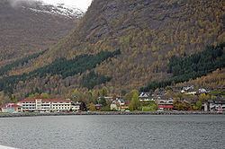 | ||
Skei (also known as Skei i Jølster) is the administrative centre of the municipality of Jølster in Sogn og Fjordane county, Norway. The village is located at the northeastern end of the lake Jølstravatnet. Skei is 20 kilometres (12 mi) south of the village of Byrkjelo (in Gloppen Municipality), 25 kilometres (16 mi) northwest of the villages of Vassenden/Langhaugane, and about 13 kilometres (8.1 mi) west of the village of Ålhus. Skei is located just west of Jostedalsbreen National Park. The village lies at the intersection of two major regional highways: European route E39 and Norwegian National Road 5.
Contents
Map of 6843 Skei, Norway
The 0.52-square-kilometre (130-acre) village has a population (2013) of 438, giving the village a population density of 842 inhabitants per square kilometre (2,180/sq mi). The village of Helgheim, where the Helgheim Church is located, sits about 4 kilometres (2.5 mi) west of Skei on the northern shore of the lake Jølstravatnet.