
Traversed by Montana Highway 38 Elevation 2,212 m | Topo map USGS Skalkaho Pass Road Montana Highway 38 | |
 | ||
Similar Bitterroot River, Lost Trail Pass, Rocky Mountains, Riverside, Lost Trail Powder Mountain | ||
The Skalkaho Pass (Salish: Sq̓x̣q̓x̣ó, "many trails" ), 7,258 feet (2,212 m) above sea level, is a pass in the Sapphire Mountains in southwest Montana traversed by Montana Highway 38.
Map of Skalkaho Pass, Montana 59858, USA
The road over the pass connects the towns of Hamilton in the Bitterroot Valley and Philipsburg in Flint Creek Valley and remains the only direct route between these two important agricultural areas. Originally an Indian route, Highway 38 was built in 1924 to link mountainous mining areas with the agricultural settlements in the valleys. The route is closed during winter due to heavy snowfall.
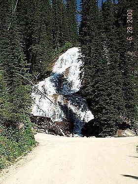
Skalkaho Falls (46°15′28″N 113°49′36″W) is near the top of the pass.
References
Skalkaho Pass Wikipedia(Text) CC BY-SA