
Elevation 497 m Population 136 (1 Jan 2016) | Region Plzeň Postal code 337 01 Area 6.43 km² | |
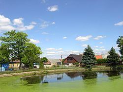 | ||
Sirá is a village and municipality (obec) in Rokycany District in the Plzeň Region of the Czech Republic.
Map of 337 01 Sir%C3%A1, Czechia
The municipality covers an area of 6.43 square kilometres (2.48 sq mi), and has a population of 105 (as at 3 July 2006).
Sirá lies approximately 14 kilometres (9 mi) north-east of Rokycany, 28 km (17 mi) east of Plzeň, and 58 km (36 mi) south-west of Prague.
References
Sirá Wikipedia(Text) CC BY-SA