
 | ||
The Simla Accord, or the Convention Between Great Britain, China, and Tibet, [in] Simla, was a treaty concerning the status of Tibet negotiated by representatives of the Republic of China, Tibet and the United Kingdom in Simla in 1913 and 1914.
Contents
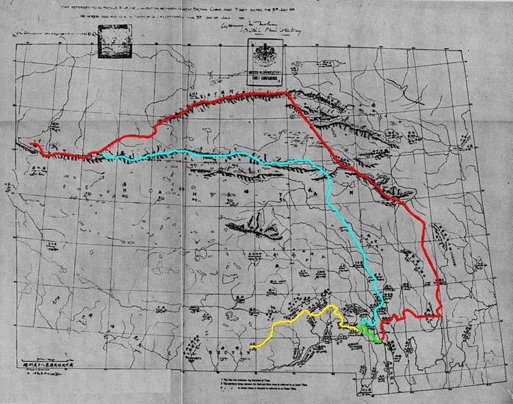
The Accord provided that Tibet would be divided into "Outer Tibet" and "Inner Tibet". Outer Tibet, which roughly corresponded to Ü-Tsang and western Kham, would "remain in the hands of the Tibetan Government at Lhasa under Chinese suzerainty, but China would not interfere in its administration. "Inner Tibet", roughly, equivalent to Amdo and eastern Kham, would be under the jurisdiction of the Chinese government. The Accord with its annexes also defines the boundary between Tibet and China proper and between Tibet and British India (the latter became known as the McMahon Line).
China rejected the Accord and their plenipotentiary, Ivan Chen, withdrew on 3 July 1914. The British and Tibetan plenipotentiaries then attached a note denying China any privileges under the Accord and sealed it as a bilateral agreement the same day.
McMahon's work was initially rejected by the British government as incompatible with the 1907 Anglo-Russian Convention. This convention was renounced in 1921. The British began using the McMahon Line on Survey of India maps in 1937, and the Simla Accord was published officially in 1938.
Background
Early British efforts to create a boundary for north-east India were triggered by their discovery in the mid-19th century that Tawang, an important trading town, was Tibetan territory. Britain had concluded treaties with Qing China concerning Tibet's boundaries with Burma and Sikkim. However, Tibet refused to recognise the boundaries drawn by these treaties. British forces led by Sir Francis Younghusband entered Tibet in 1904 and made a treaty with the Tibetans. In 1907, Britain and Russia acknowledged Chinese "suzerainty" over Tibet.
British interest in the borderlands was renewed when the Qing government sent military forces to establish a Chinese administration in Tibet (1910–12). A British military expedition was sent into what is now Arunachal Pradesh and the North-East Frontier Agency was created to administer the area (1912). In 1912–13, this agency reached agreements with the tribal leaders who ruled the bulk of the region. After the fall of the Qing dynasty in China, Tibet government at Lhasa expelled all Chinese forces and declared itself independent (1913), however, this was not accepted by the newly founded Republic of China.
Conference
In 1913, the British convoked a conference at Simla, India to discuss the issue of Tibet's status. The conference was attended by representatives of Britain, the newly founded Republic of China, and the Tibetan government at Lhasa. The British plenipotentiary, Sir Henry McMahon, introduced the plan of dividing Tibetan-inhabited areas into "inner Tibet" and "outer Tibet" and apply different policies. "Inner Tibet," which includes Tibetan-inhabited areas in Qinghai, Gansu, Sichuan and Yunnan provinces, would be under the jurisdiction of the Chinese government. "Outer Tibet," covering approximately the same area as the modern "Tibet Autonomous Region" would enjoy autonomy. A boundary between Tibet and British India, later called the McMahon Line, was drawn on a map referred to in the treaty.
The Tibetan Indian boundary was negotiated in Simla between representatives from Britain and Tibet privately, in the absence of the Chinese representative. During the Simla conference a map of the Tibetan Indian border was provided as an annexe to the proposed agreement.
The Schedule appended to the Accord contained further notes. For example, it was to be understood that "Tibet forms part of Chinese territory" and after the Tibetans selected a Dalai Lama, the Chinese government was to be notified and the Chinese commissioner in Lhasa would "formally communicate to His Holiness the titles consistent with his dignity, which have been conferred by the Chinese Government"; that the Tibetan government appointed all officers for "Outer Tibet", and that "Outer Tibet" was not to be represented in the Chinese Parliament or any such assembly.
Negotiations failed when China and Tibet could not agree over the Sino-Tibetan boundary. After the Chinese plenipotentiary, Ivan Chen, withdrew from the convention, the British and Tibetan plenipotentiaries attached a note denying China any privileges under the agreement and signed it as a bilateral Accord. At the same time the British and Lochen Shatra signed a fresh set of trade Regulations to replace those of 1908.
Aftermath
Simla was initially rejected by the Government of India as incompatible with the 1907 Anglo-Russian Convention. The official treaty record, C.U. Aitchison's A Collection of Treaties, was published with a note stating that no binding agreement had been reached at Simla. Since the condition (agreement with China) specified by the accord was not met, the Tibetan government didn't agree with the McMahon Line.
The Anglo-Russian Convention was renounced by Russia and Britain jointly in 1921, but the McMahon Line was forgotten until 1935, when interest was revived by civil service officer Olaf Caroe. The Survey of India published a map showing the McMahon Line as the official boundary in 1937. In 1938, the British published the Simla Convention in Aitchison's Treaties. A volume published earlier was recalled from libraries and replaced with a volume that includes the Simla Convention together with an editor's note stating that Tibet and Britain, but not China, accepted the agreement as binding. The replacement volume has a false 1929 publication date.
In April 1938, a small British force led by Captain GS Lightfoot arrived in Tawang and informed the monastery the district was now Indian territory. The Tibetan government protested and its authority was restored after Lightfoot's brief stay. The district remained in Tibetan hands until 1951.
In the late 1950s, the McMahon Line became a source of tension between China and India. China contends that Tibet was never an independent state and so it could not sign a treaty on behalf of China to delineate an international frontier. China and India fought the Sino-Indian War in 1962, which nevertheless preserved the status quo ante bellum. Years later, the area, then known as the North-East Frontier Agency, gained Indian statehood as Arunachal Pradesh.
2008 British policy change
Until 2008 the British Government's position remained the same that China held suzerainty over Tibet but not full sovereignty. It was the only state still to hold this view. David Miliband, the British Foreign Secretary, described the old position as an anachronism originating in the geopolitics of the early 20th century. Britain revised this view on 29 October 2008, when it recognised Chinese sovereignty over Tibet by issuing a statement on its website.The Economist stated that although the British Foreign Office's website does not use the word sovereignty, officials at the Foreign Office said "it means that, as far as Britain is concerned, 'Tibet is part of China. Full stop.'"
The British Government sees their new stances as an updating of their position, while some others have viewed it as a major shift in the British position. Tibetologist Robert Barnett thinks that the decision has wider implications. India's claim to a part of its north-east territories, for example, is largely based on the same agreements – notes exchanged during the Simla convention of 1914, which set the boundary between India and Tibet – that the British appear to have just discarded. It has been speculated that Britain's shift was made in exchange for China making greater contributions to the International Monetary Fund.