
Elevation 1,418 m (4,652 ft) Parent range Basque mountains Highest point Ioar Translation Basque language Mountains Ioar | Location Navarre, Spain First ascent unknown Range Basque Mountains Easiest route Climbing | |
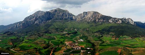 | ||
The Codés Range (Kodesko mendilerroa in Basque and Sierra de Codés in Spanish) is a mountain range of western Navarre, Spain, part of the Basque Mountains. Its highest point is the 1,418 metres high Ioar, located between Santa Cruz de Campezo and Aguilar de Codés. The Codés Range is the westernmost mountain range in Navarre, located right at the limit of Álava Province.
The Santuario de Nuestra Señora de Codés is located in this mountain range, within the Torralba del Río municipal term.
Together with the neighboring Andia and Urbasa ranges further north, Codés summits are usually covered in snow in the winter.
Summits
References
Sierra de Codés Wikipedia(Text) CC BY-SA