
Gaelic name Siùna Area rank 121 Area 155 ha Lieutenancy area Argyll and Bute | OS grid reference NM916490 Sovereign state United Kingdom Council area Argyll and Bute | |
 | ||
Meaning of name Probably "sea island" from Norse Highest elevation Tom an t-Seallaidh 71 m (233 ft) Island groups British Isles, Inner Hebrides | ||
Shuna Island is an island in Loch Linnhe, offshore from Appin. The island is approximately 2 kilometres (1.2 mi) long and 1 kilometre (0.62 mi) wide and extends to some 155 ha (383 acres) in total. The island is characterised by a table topped hill at its southern end. The name Shuna is probably derived from the Norse, for "sea island".
Map of Shuna Island, United Kingdom
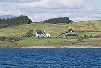
Shuna is recorded in a late 16th century document as belonging to John Stewart, the Laird of Appin. He may have built Castle Shuna a small tower-house, which is now in ruins lies at the south end In the 18th century, Shuna Farmhouse replaced Castle Shuna as the residence on the island: it is a Category B listed traditional farmhouse dating from the 1740s. Opposite Castle Shuna, at the head of Loch Laich, is the island fortress of Castle Stalker, also historically a possession of the Stewarts of Appin.
The island forms part of the Lynn of Lorn National Scenic Area, one of 40 in Scotland.
In 2012 the island was placed on sale via agents Savills for £1.85 million.