
Population 2,342 (2011) Region East Sovereign state United Kingdom Local time Sunday 7:48 AM District Babergh | OS grid reference TM2463 Country England Post town Ipswich Shire county Suffolk Dialling code 01473 | |
 | ||
Weather 7°C, Wind NW at 8 km/h, 83% Humidity | ||
Shotley is the parish giving its name to the Shotley peninsula south of Ipswich, between the River Stour and the River Orwell in Suffolk, England. Shotley parish comprises the village of Shotley and the larger adjacent settlement of Shotley Gate. In 2001 there were 2,373 people living in Shotley.
Contents
- Map of Shotley Ipswich UK
- Shotley
- Shotley Gate
- Amenities and places of interest
- Coastal footpath erosion
- HMS Ganges site redevelopment
- In popular culture
- References
Map of Shotley, Ipswich, UK
Shotley
The village of Shotley is about a mile northwest from the tip of the peninsula, and lies either side of the B1456 road (the Street). There are two entries for Shotley (Scoteleia) and an adjacent settlement of Kirkton (Cherchetuna) listed in the Domesday Book of 1086.
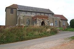
A school is located outside the village (half of 1 km east) opposite the turning into Oldhall Road. Oldhall Road is located east of the village leading north to St Mary's Church. The church contains a naval cemetery cared for by the Commonwealth War Graves Commission.
Shotley Hall is located near to the church. Rose Farm lies to the south of the village.
Shotley Parish Council holds its main meeting at the village hall at 19.00 hours every third Thursday of every month, while the Open Spaces and Amenities Committee meets most months on the second Thursday. Both are open to the public.
Shotley Gate
Shotley Gate is a settlement to the south of the village of Shotley at the tip of the peninsula.
By about 800 AD, the Vikings or Danes started to make an appearance in this area. Under the Peace of Wedmore in 878, all land north of the old Roman Watling Street, which ran from London to Chester, was given to the Viking leader, Guthrum. Shotley therefore became part of Danelaw. The peace was short-lived however, and following an unsuccessful Viking attack on Kent, Alfred King of Wessex attacked the enemy in East Anglia. The Anglo-Saxon Chronicle for the year 885 reads as follows: 'The same year sent King Alfred a fleet from Kent into East Anglia. As soon as they came to Stourmouth, there met them sixteen ships of the pirates, and they fought with them, took all the ships and slew the men. As they returned homeward with their booty, they met a large fleet of pirates and fought with them the same day, but the Danes had the victory'. It is possible that Bloody Point at Shotley took its name from this incident, however at that time the river entered the sea north of Felixstowe and so the area would not have been seen as the mouth of the Stour. It could also have derived this name late in the next century when the Vikings returned to the estuary in force, twice plundering Ipswich. Shotley Gate and the parish have a strategic position for protecting the ports of Felixstowe, Harwich and Ipswich and in 1865 the Shotley Battery fortifications were established.
Shotley Gate also harbours HMS Ganges, a former Royal Navy training establishment (RNTE Shotley) for boys. The teak ship was constructed in 1821 and taken out of service in 1861. It was moved to Shotley in 1899, and by 1905 was moved ashore. The training establishment closed in 1976 and the site was subsequently sold for redevelopment. In June 2011 Babergh District Council declared the site a Conservation Area.
The HMS Ganges Museum (open Saturdays, Sundays and Bank Holidays between Easter and the end of October 1100 to 1700hrs) houses artefacts and memorabilia from the old shore establishment including a large collection of photographs and original documents.
Amenities and places of interest
The Rose public house is situated in the village of Shotley. The Bristol Arms public house lies in Shotley Gate near the piers and Martello towers. The Shipwreck public house is located at Shotley Marina, also in Shotley Gate at the end of King Edward VII Drive – a popular tourist destination.
In the summer months a foot and cycle ferry service licensed to carry up to 12 passengers operates between Shotley Marina, Harwich and Felixstowe.
There are a number of listed buildings located in Shotley, including Martello towers and the ceremonial mast from the former HMS Ganges. Shotley Cottage (half of 1 km southeast of the village of Shotley) was a World War I radio telegraphy station. The Suffolk Historic Environment Record lists more than 200 sites and monuments in Shotley.
St Mary's Church Walking Club, Shotley, meets on the second Sunday of every month.
Coastal footpath erosion
In 2008 the collapse of a section of the footpath which runs along the base of Shotley Cliff (which was subsequently reinstated by Shotley Parish Council) drew attention to a coastal erosion issue affecting a lengthy exposed section of the cliff further along, where the path had already crumbled away. It became apparent that the cliff was eroding at a rate not previously recognised, which was likely to endanger several properties above it.
A group of local residents in Shotley Gate, informally known as the Shotley Stour Footpath Renovation Group, began a long term project to deal with the issue, which eventually led to the Group (with assistance from the Parish Council) obtaining funding for sea defences to protect the first 90 metres (295 ft) of the exposed area from a number of sources including Suffolk County Council, the Environment Agency, the Haven Gateway Partnership, Hutchison Ports, Suffolk Coasts & Heaths and Shotley Parish Council, as well as local fundraising; in total, these defences (which were installed by Welham Plant Ltd under the project management of the Stour Footpath Group and Hawes Associates) cost just under £40,000 to install, with a further £60,000 subsequently raised for defences along the remaining 120 metres (394 ft) of exposed cliff and for the renovation of a derelict picnic area at the other end of the footpath, both hopefully to be completed in 2011 (£18,000 of this funding came as a result of the Shotley project winning the Haven Gateway Authority's 'I Love Landscapes' competition in May 2011, the project receiving 1413 votes from the public).
Phase two of the sea defence work began on 11 July 2011, extending the defences to the far end of Shotley Cliff and creating a maintenance path to the rear of them which effectively links the remains of two public footpaths to create a continuous coastal path (albeit one which in theory is not a 'public footpath' for the entirety of its length). The sea defences, as well as the newly renovated Shotley Gate Picnic Area at the other end of the footpath, were formally opened by Tim Yeo MP on the morning of 19 September 2011, an event which was also broadcast on BBC Radio Suffolk. The project has been written up by the Estuaries Officer and Suffolk County Council as a case study in inter-agency co-operation with the public. Most of Shotley Cliff and fifty acres of foreshore, including the land on which the sea defences sit, was purchased by Shotley Parish Council late in 2012, and the Council now has responsibility for ongoing maintenance and management of the area.
The public footpath (The Stour and Orwell Walk) between Shotley Gate and Pin Mill is currently closed off by Suffolk County Council from about 2 km north of Shotley Gate marina (where it branches to Church End) as far as the Orwell Cottages near Colton Creek until mid August 2014 as a result of recent tidal surge which caused significant erosion. No alternative route is available.
HMS Ganges site redevelopment
The attempted development of the former HMS Ganges site has caused considerable controversy in the area over several years. The scale of the proposed development was felt by residents in both Shotley and other villages along the B1456 to be in excess of what the local infrastructure could cope with. In November 2010 planning permissions on the site lapsed following an unsuccessful appeal by the developer. The mast which stands in what was formerly the parade ground is currently due for repair.
The HMS Ganges site remains undeveloped and its future is uncertain. In April 2012 the developers submitted a revised proposal for 285 homes, a 60-bed nursing home, a hotel, offices, shops and community facilities. The site has had planning permission granted in principle and the land will take two years to clear before building works begin.