Area 239 km² Local time Sunday 7:29 AM | Phone number 019-672-2111 Population 32,782 (Sep 2015) Bird Barn swallow | |
 | ||
Weather 2°C, Wind SW at 11 km/h, 88% Humidity Points of interest Joyama Park, Azumaneyama, Shiroyama | ||
Shiwa (紫波町, Shiwa-chō) is a town located in Iwate Prefecture, in the Tohoku region of northern Japan. As of September 2015, the town had an estimated population of 32,782 and a population density of 137 persons per km2. The total area was 238.98 square kilometres (92.27 sq mi).
Contents
- Map of Shiwa Shiwa District Iwate Prefecture Japan
- Geography
- Neighboring municipalities
- History
- Economy
- Railway
- Highway
- International relations
- Noted people from Shiwa
- References
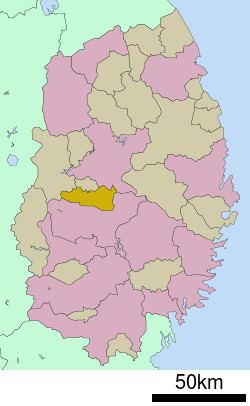
Map of Shiwa, Shiwa District, Iwate Prefecture, Japan
Geography
Shiwa is located in central Iwate Prefecture.
Neighboring municipalities
History
The area of present-day Shiwa was part of ancient Mutsu Province, and has been settled since at least the Jomon period. The area was inhabited by the Emishi people, and came under the control of the Yamato dynasty during the early Heian period. During the Sengoku period, the area was dominated by various samurai clans before coming under the control of the Nambu clan during the Edo period, who ruled Morioka Domain under the Tokugawa shogunate. Shiwa prospered as a post station on the Ōshū Kaidō highway connecting Edo with the northern provinces.
The town of Hizume and the villages of Furudate, Mizuwake, Shiwa, Akaishi, Hikobe, Sahinai, Akasawa, ane Nagaoka were established within Shiwa District on April 1, 1889. These municipalities were merged on April 1, 1955 to form the town of Shiwa.
Economy
The local economy of Shiwa is traditionally based on agriculture, primarily rice cultivation; however, due to its proximity to Morioka city, it is increasingly serving as a bedroom community.
