
Lifespan T.A. 1601 – Fourth Age | ||
 | ||
Other name(s) Sûza, Sûzat (Westron)
i Drann (Sindarin) Type Secluded area settled exclusively by Hobbits Ruler Thain and Mayor of the Shire Notable locations Bag End, Buckland, Hobbiton, the Woody End Location central west of Eriador / Arnor First appearance The Hobbit, The Fellowship of the Ring | ||
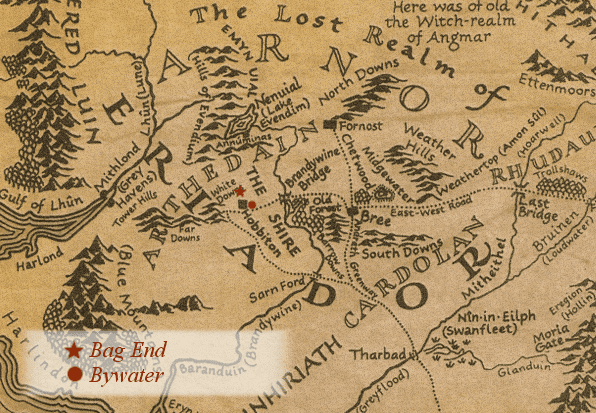
The Shire is a region of J. R. R. Tolkien's fictional Middle-earth, described in The Lord of the Rings and other works. The Shire refers to an area settled exclusively by Hobbits and largely removed from the goings-on in the rest of Middle-earth. It is located in the northwest of the continent, in the large region of Eriador and the Kingdom of Arnor. In the languages invented by Tolkien, its name in Westron was Sûza "Shire" or Sûzat "The Shire", while its name in Sindarin was i Drann.
Contents
Geography
According to Tolkien, the Shire measured 40 leagues (193 km, 120 miles) from the Far Downs in the west to the Brandywine Bridge in the east, and 50 leagues (241 km, 150 miles) from the northern moors to the marshes in the south. This is confirmed in an essay by Tolkien on translating The Lord of the Rings, where he describes the Shire as having an area of 18,000 square miles (47,000 km2).
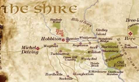
The original territory of the Shire was bounded on the east by the Baranduin River, on the north by uplands rising to the old centre of Arnor, on the west by the White Downs, and on the south by marshland south of the River Shirebourn. After the original settlement, hobbits also expanded to the east into Buckland between the Baranduin and the Old Forest, and (much later) to the west into the Westmarch between the White Downs and the Tower Hills.
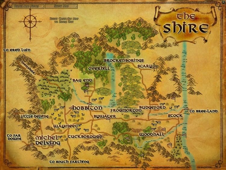
The Shire was originally divided into four Farthings. The outlying lands of Buckland and the Westmarch were formally added after the War of the Ring. Within the Farthings there are some smaller unofficial clan homelands: the Tooks nearly all live in or near Tuckborough in Tookland, for instance. A Hobbit surname often indicates where the family came from: Samwise Gamgee's last name derives from Gamwich, where the family originated. Buckland was named for the Oldbucks (later called the Brandybucks).
The Shire is described as a small but beautiful, idyllic and fruitful land, beloved by its inhabitants. The Hobbits had an extensive agricultural system in the Shire but were not industrialised. The landscape included small pockets of forest (again similar to the English countryside). Various supplies were produced in the Shire, including cereals, fruit, wood and pipe-weed.
Regions of the Shire
The original parts of the Shire were subdivided into four Farthings ("fourth-ings" or "quarterings"). The Three-Farthing Stone marked the tripoint where the borders of the Eastfarthing, Westfarthing and Southfarthing of the Shire came together, by the East Road. (Iceland was traditionally also divided in Farthings, or "fourth parts", as the Shire is.) It is claimed that the Three-Farthing Stone was inspired by the Four shire stone.
Buckland, across the Baranduin River to the east, and the Westmarch, between the Far Downs and the Tower Hills to the west, were not part of the original grant to the hobbits by King Argeleb II of Arthedain. These were formally given to the hobbits as the East and West Marches of the Shire by King Elessar after the War of the Ring, in S.R. 1462 (F.A. 41). Buckland had been long settled by then: Gorhendad Oldbuck led hobbits from the East Farthing across the river in T.A. 2340, and Buckland became "sort of a colony of the Shire". There is no mention of settlement in the Westmarch until Elessar's gift; Sam Gamgee's daughter Elanor and her husband Fastred later settled there, and Fastred was named Warden of Westmarch.
Northfarthing
The Northfarthing was the least populous part of the Shire. It was where most of the Shire's barley crop was grown, and the only farthing where heavy snow was frequent. The historic Battle of Greenfields was fought here.
Westfarthing
The western part of the Shire. It extended from the Three-Farthing Stone west to the Far Downs, and included the White Downs.
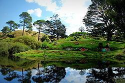
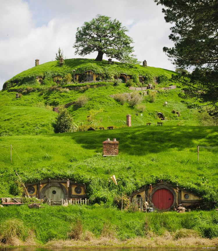
The Hobbit, the first well-known work set in Middle-earth, opens and closes in Bag End, and The Lord of the Rings closes there. Bag End as a starting-point for adventure is referenced as 'the door where it began' in the song The Road Goes Ever On. Bag End was built circa T.A. 2885, by the wealthy and respected Bungo Baggins as a wedding gift for his bride Belladonna Took, one of numerous children of the Shire's Thain, the great Gerontius Took. Their son Bilbo inherited the smial in his adult bachelorhood on the death of his parents. The windows and front door of Bag End were round, a typical feature of hobbit-architecture. Its tunnels and rooms, also typically, were all built on one level. However, only lavish smials like Bag End had many rooms and cellars, with high-quality fixtures, fittings, and furniture. Its front door (on the south) and the porthole-like windows (all on the west) opened onto Bag End's lawns and gardens, the Party Field, and the distant countryside beyond. The main entrance sat on the end of a gated path at the end of a lane leading from the Hill Road. Just to the south of Bag End lay Bagshot Row, a lane built on top of fill literally tossed over the south side of The Hill while Bag End was being excavated. Bilbo later added a potato garden to the western slope when Hamfast "Gaffer" Gamgee, of Number 3, Bagshot Row became his full-time gardener in T.A. 2961. Gamgee himself often employed Holman Greenhand who lived in a hut south of The Water. Gamgee's neighbor, Daddy Twofoot, lived in Number 2. Tolkien borrowed "Bag End" from the name of his aunt's farmhouse in the Worcestershire village of Dormston. It was supposedly intended as a translation of the word Labin-nec in the fictional Westron language. This had much the same meaning, and a similar relationship, to Labingi (the Westron form of Baggins) as Bag End to Baggins. The author's visualization of Bag End can be found in his illustrations for The Hobbit. His watercolour The Hill: Hobbiton-across-the Water shows the exterior and the surrounding countryside, whilst The Hall at Bag-End [sic] depicts the interior.Southfarthing
The Southfarthing was the site of Longbottom, where the best pipe-weed was grown, owing to the area's warmer climate. The area was also known for the production of wine, principally Old Winyards, a "strong red wine".
Eastfarthing
The Eastfarthing bordered Buckland and contained the towns of Frogmorton and Whitfurrows on the ancient Great East Road, and the farms of the Marish. The farmers near the Brandywine river largely acknowledged the authority of the Oldbucks, even after the latter moved across the river and became the Brandybucks.
Buckland
Not originally part of the Shire, Buckland lay east of the Baranduin (Brandywine) river. The area was protected from the nearby Old Forest by the "High Hay", a tall hedge which formed the eastern border of Buckland, running from the Brandywine Bridge in the north to the confluence of the Withywindle with the Baranduin near the village of Haysend in the south. The main entrance to Buckland from the north was a gate in the Hay, called variously the Buckland Gate, the North Gate, or the Hay Gate, located "where the Hedge runs down to the river-bank, just this side of the Bridge," opening onto the East Road from the Shire to Bree.
Unlike other hobbits, the Bucklanders were more prepared for danger and less naive than the Shire-hobbits. They closed the Hay Gate and locked their own front doors at night, and had a warning signal - the Horn of Buckland - to enable quick mobilization. Most Bucklanders were originally of Stoor stock, and they were the only hobbits known to use boats.
Westmarch
After the events of the War of the Ring at the start of the Fourth Age, King Elessar granted the hobbits of the Shire effective self-rule inside his reunited kingdom, banning any Men from entering the land without the permission of the hobbits.
He also granted the Shire a stretch of new land: this reached from the ancient western borders of the Shire, the Far Downs, to the Tower Hills. The area between the downs and the hills became known as the Westmarch. Like Buckland, it was not part of any of the four Farthings.
The eldest daughter of mayor Samwise Gamgee, Elanor the Fair, married Fastred of Greenholm, and they moved to the Westmarch, settling in Undertowers. After the passing of master Samwise into the Grey Havens, they and their children became known as the Fairbairns of the Towers or Wardens of Westmarch. The Red Book of Frodo and Bilbo Baggins passed into their keeping, becoming known as the Red Book of Westmarch.
History
The Shire was first settled by Hobbits in the year 1601 of the Third Age (Year 1 in Shire Reckoning); they were led by the brothers Marcho and Blanco (modelled on Hengist and Horsa). The Hobbits (who originally lived in the vale of Anduin) had migrated west over the perilous Misty Mountains in the decades before that, and before entering the Shire they had lived in Dunland and parts of the depopulated Arnorian splinter-realms Cardolan and Rhudaur. It has been speculated that the Hobbits had originally moved west to escape the troubles of Mirkwood, and the evil caused by the Easterlings.
The Shire was a part of Arthedain, and as such a part of Arnor. The Hobbits obtained official permission from King Argeleb II at Norbury (Fornost) to settle the lands, which were no longer populated and were seen as the king's hunting grounds. The King stipulated three conditions to this grant; that the hobbits should acknowledge his Lordship, that they should maintain the roads within the Shire and finally that they should aid his messengers. The Hobbits therefore considered themselves subjects of the king and sent some archers to the great battles Arnor fought against Angmar. After the fall of Arnor, the Shire remained a minor but independent, self-governing realm. The Shirefolk chose an official named the Thain to hold the king's powers after the North-kingdom fell. The first Thains were the heads of the Oldbuck clan. The position later came to be held by the Tooks.
Its small size, relative lack of importance, and brave and resilient Hobbit population made it too modest an objective for conquest. More importantly, the Shire was guarded and protected by the Dúnedain Rangers, who watched the borders and kept out intruders. The only strangers to enter the Shire were the Dwarves travelling on the Great Road that ran through the Shire to and from their mines in the Blue Mountains, and the occasional Elves on their way to the Grey Havens.
This peaceful situation changed after Bilbo Baggins's acquisition of the One Ring in the year 1341 of the Shire Reckoning (Third Age 2941). Shortly after the beginning of the events described in The Lord of the Rings (autumn of S.R. 1418), the Shire was first visited by the Nine Ringwraiths and then captured by Saruman through his underling Lotho Sackville-Baggins, who turned the Shire into a police state and began a massive campaign to industrialize it, bringing widespread misery and severely damaging its ecology. It was liberated with the help of Frodo, Sam, Merry, and Pippin after the end of the Quest of the Ring through their victory at the Battle of Bywater. After Aragorn's return as the King of Arnor and Gondor, the Shire became a protected enclave inside the Reunited Kingdom. Aragorn is known to have issued an edict that forbade the entrance of full-sized Men into the Shire. The Shire was soon restored with magic soil from Galadriel's Lórien garden (presented as a gift to Sam). The year S.R. 1420 was considered by the inhabitants of the Shire to be the most productive and prosperous year in their history.
Government
The Shire was a voluntarily orderly society. The only government services were the Message Service (the post) and the Watch, the police, whose officers were called Shirriffs, and whose chief duties involved rounding up stray livestock. The total number of regular Shirriffs was 12, three for each Farthing. There was also a somewhat larger and fluctuating number of Bounders, a kind of unofficial border control. At the beginning of The Lord of the Rings, there were many more Bounders than had been required for centuries, and they were unusually busy: one of the few signs obvious to the Hobbits of the Shire of the troubled times.
To a large extent, individual families and clans handled their own internal affairs. Where a prominent family was associated with a certain district, the head of that family would also exercise a kind of authority over his area. Thus, the Master of the Hall or Master of Buckland (the two titles are used interchangeably), hereditary head of the Brandybuck clan, was the effective ruler of Buckland. The title Master of the Hall comes from his more immediate authority over Brandy Hall, the greatest of the dwelling places of the Brandybuck family, filling Buck Hill in Bucklebury. The Master also exercises a good deal of authority in the Marish, a region of the Eastfarthing just across the Brandywine River from Buckland. Similarly, the head of the Took clan, often just called the Took, ruled the ancestral Took dwelling of Great Smials, the village of Tuckborough, and the wider area known as the Tookland.
There were only two Shire-wide officials, the Thain and the Mayor. The Thainship was a hereditary office, set up after the collapse of the Kingdom of Arthedain, to hold the King's authority over the Shire. In practice, the Thain's duties were limited, mostly related to defence: "The Thain was the master of the Shire-moot, and captain of the Shire-muster and the Hobbitry-in-arms; but as muster and moot were only held in times of emergency, which no longer occurred, the Thainship had ceased to be more than a nominal dignity." Nevertheless, the feeling remained widespread that, in the absence of a King, the Thain was the source for all proper authority in the Shire, and during Saruman's intervention in the Shire in S.R. 1419, Thain Paladin II, aided by many Hobbits and particularly his Took clan, led armed opposition to Saruman's forces from his capital at Tuckborough.
When Frodo Baggins left the Shire at the outset of The Lord of the Rings S.R. 1418, the office of Thain had existed for 1,039 years. The first Thain, Bucca of the Marish, took office in S.R. 379; he and his 11 successors of the Oldbuck family held the Thainship for 361 years. When Gorhendad Oldbuck led his family to settle Buckland (S.R. 740), the office of Thain passed to Isumbras I, head of the Took family, which held the Thainship ever since. In S.R. 1418, the Thain was Paladin II, the 31st Thain and the 19th of the Took line.
Thains of the Shire include (years are in Shire Reckoning):-
The chief official of the Shire was the Mayor of Michel Delving. Elected every seven years at the "Free Fair" held on the White Downs in the Westfarthing, the Mayor was the Postmaster and First Shirriff of the Shire.
The Hobbits of the Shire generally obeyed the Rules, that is, the ancient laws of the North Kingdom, and there was no real need to enforce them; all Hobbits voluntarily obeyed them as they were both ancient and just. Hobbits had lawyers, but these dealt mostly with wills and such matters; there is no record of a formal court system, still less of criminal prosecutions or punishments. Frodo stated that in the Shire no Hobbit had ever been known intentionally to kill another Hobbit. Sméagol's wicked behaviour, including his murder of Déagol (which occurred outside the Shire), led Frodo to doubt that Sméagol was a hobbit at all. Of course, it is probable that Sméagol's treachery was the result of the Ring's influence; the books make it clear that the Ring could tempt individuals to perform terrible acts.
At the resumption of the throne by King Elessar, the Shire again became part of the restored Kingdom of Arnor. Elessar permitted the Hobbits to keep their own laws and customs. (The office of Thain was also left undisturbed, though now, as intended, subject to and local steadholder of the King of Arnor.) In 1427, Elessar issued an edict prohibiting Men from entering the Shire and declaring it a Free Land under the protection of Arnor.
Inspiration
On Tolkien's maps, the Shire is located at about the same position as England is on modern European maps and has been cited as an example of Merry England ideology. Throughout the narrative, Tolkien also implies numerous points of similarity between the two, such as weather, agriculture and dialect.
In particular, the central part of the Shire corresponds to the West Midlands region of England, extending to Worcestershire (where Tolkien located his "home" in particular, his mother's family being from Evesham), Gloucestershire, Shropshire, Warwickshire, Herefordshire and Staffordshire, as argued by Tom Shippey forming a "cultural unit with deep roots in history". The Northfarthing, with its heavy snowfalls, may correspond to Yorkshire or the Lake District, while the Southfarthing lay far enough south to support the cultivation of wine and tobacco ("pipe-weed"). Tolkien said that pipe-weed "flourishes only in warm sheltered places like Longbottom." In the seventeenth century, Worcestershire, in particular the area of Evesham, was well known as an area where tobacco was cultivated.
The name "Shire" harks back to T. H. White's book England Have My Bones, where White says that he lives in "the Shire" (with a capital "s").
Hooker observes that the Sindarin i drann is a loanword from Welsh, where tran means district, or a region. The Welsh word tran will mutate to dran under certain grammatical conditions, for example: when it is preceded by the Welsh definite article y.
The industrialisation of the Shire was based on Tolkien's childhood experience of the blighting of the Worcestershire countryside by the spread of heavy industry. The rebellion of the Hobbits and the restoration of the pre-industrial Shire may be interpreted as a prescription of voluntary simplicity as a remedy to the problems of modern society. Saruman, the character responsible for the pollution of the Shire, derives his name partly from Sarehole Mill, in the vicinity of which Tolkien spent "the most idyllic period" of his childhood. The Shire is imagined as the West Midlands in a more remote past, akin to the Old English kingdom of Mercia, aspects of which serve also as a model for the Mark of the Rohirrim.
Film
The Shire makes an appearance in both the 1977 The Hobbit and the 1978 The Lord of the Rings animated films.
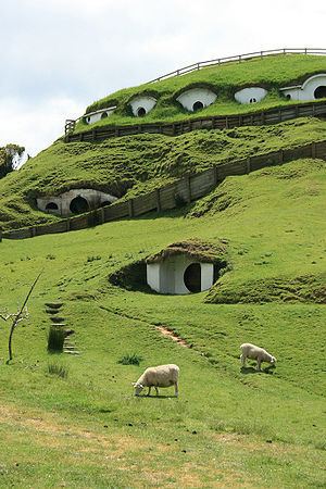
In The Lord of the Rings motion picture trilogy, the Shire appeared in both The Fellowship of the Ring and The Return of the King. The Shire scenes were shot at a location in Matamata, New Zealand. Following the shooting, the area was returned to its natural state, but even without the set from the movie the area became a prime tourist location.
The Shire was revisited by Peter Jackson for The Hobbit: An Unexpected Journey. The Shire scenes were shot at the same location in Matamata, New Zealand. Unlike the previous set, Hobbiton was constructed out of permanent materials so that it will last for several decades.
Games
In the 2006 Real-Time Strategy Game The Lord of the Rings: The Battle for Middle Earth II, the Shire appears as both a level in the evil campaign where the player invades in control of a goblin army, and as a map in the game's multiplayer skirmish mode.
In the 2007 MMORPG The Lord of the Rings Online, the Shire appears almost in its entirety as one of the major regions of the game. The shire is inhabited by hundreds of Non-player characters, and the player can get involved in hundreds of quests. The only portions of the original map by Christopher Tolkien that are missing from the game are some parts of the West Farthing and the majority of the South Farthing. A portion of the North Farthing also falls within the in-game region of Evendim for game play purposes.
In the 2009 action game The Lord of the Rings: Conquest, the Shire appears as one of the game's battlegrounds during the Evil campaign, where it is razed by the forces of Mordor.
In the 2011 Role-playing video game The Lord of the Rings: War in the North, the Shire appears briefly in a cut scene showing the Nazgûl breaking through the Rangers' defenses at Sarn Ford.
Games Workshop also produced a supplement in 2004 for The Lord of the Rings Strategy Battle Game entitled The Scouring of the Shire. This supplement contained rules for a large number of miniatures that depicted the Shire after the War of the Ring had concluded.